- Friday, 22 May 2026
Through The Kaligandaki Gorge To Muktinath
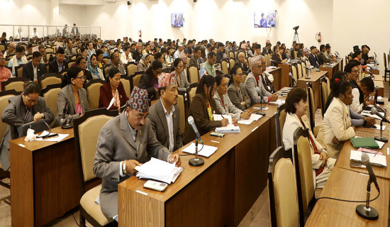
Tour culture is thriving in Nepal lately and so is the need to have a planned itinerary. And carrying one’s own food items, utensils and bedding, that our fathers and grandfathers practised, has already become a thing of the past. At the end of tiresome travel on the road, looking for a place of dining and a night's rest at the eleventh hour can be a nightmare. In our own case, finding a package tour operator became preferable and handy for this reason.
They suggested that the best times of the year to visit Mukti Chhetra and explore the unmatched beauties of Mustang are spring and autumn. We chose the former and set out in a Scorpio jeep from a Kathmandu-based travel agency that operates package tours all over Nepal. A payment of Rs. 12,500 liberated us from the need to arrange vehicles and places of dining and lodging at the individual level. During this peak season of Mustang travel, it is necessary to book lodges and order lunch and dinner in advance.
Modes of travel to Muktinath and Upper Mustang vary. Some people go for a faster way of taking a flight to Pokhara and then another flight from Pokhara to Jomsom. This takes you very close to Kagbeni and Muktinath, but the traveller misses a lot of the ground-based life, landscape and unique natural surroundings that form the Kaligandaki area. A travel through land transport, by motorbikes, jeeps and tourist buses or hiking, offers sightseeing stops at interesting destinations along the way. They include the cliff-bee hives along Modi Khola, suspension bridges of record height and length, an exceptionally high bungee jump site, hot water springs and waterfalls.
Religious sites one can visit along the route to Muktinath include the mid-woodland Baglung Kalika temple near Baglung Bazar and Galeshwar Dham, located on the bank of the Kaligandaki in the Myagdi district and built on a huge Saligram rock. Fossilised black Saligram rocks, strewn along Kaligandaki, are worshipped as holy objects in Nepali homes. Geologists describe it as an ammonite fossil from the bed of the Tethys Sea, which existed here before the tectonic rise of the Himalayas. This is an important site for researchers because the river cuts through and exposes geologically important sedimentary rock layers, providing scientific clues on Himalayan tectonic evolution.
The Kaligandaki is regarded as the oldest river and the gorge it has created is the deepest in the world. This unique geological formation has made it possible to build Nepal’s highest and the world’s second-highest bungee jumping site over the Kaligandaki along with zip-lining and sky-swinging facilities at Kusma of Parbat district. Those who love adventure in nature come here from around the world for thrilling experiences. Several stunningly long suspension bridges have been built over the Kaligandaki that connect Parbat and Baglung districts.
The Mugling-Pokhara journey is now a pleasant driving experience with the construction of the wide, state-of-the-art highway to the lake city. Even further west from downtown Pokhara, the well-built road passing through Simpani and Hemja has been famed as Viral Road as travellers record and post their cruising experience in photos and videos on the social sites. The scenic double-lane road extends up to the start of the Pokhara-Baglung highway at Phedi. Further ahead, the winding road passes through the cool, foggy and rainy hills of Kande, Australian Camp and Lumle until it climbs down to Naya Pul, from where the hiking trail to Ghandruk starts to the north.
Nobody has to complain about road conditions from Pokhara through Kusma, Maldhunga, Golden Bridge, Myagdi district headquarters Beni and Galeswar Bazaar until the driving gets somewhat scary through the Tatopani area of the Beni-Jomsom Highway. During our mid-Baisakh (early May) tour, heavy rains had fallen in this area at night, causing landslides here and there. We heard the news of the road being damaged by landslides during our first night stay at Galeshwar Bazar, raising fears that getting to Muktinath for a holy bath and worship might be delayed. But by the morning, we were told that the road obstructions were cleared. Nevertheless, the condition of the road was still far from good.
“This section of the highway is risky with rockfalls and erosion. If the road was damaged, we used to get stranded without food and water, as teashops and lodges are not around,” said our driver, Prakash. Here, the road is narrow, constructed by cutting through precipitous cliffs below which the Kaligandaki roars through a narrow gorge.
Road workers were clearing the flood debris, and larger buses were struggling to cross the obstructions. As we crossed this section of the highway, we were relieved that the rain-affected obstructions were over. That made us happy. After registering an entry at the Dana Area Police Post, our vehicle started its upward climb along the winding hill road with the Rupse waterfall roaring on our left side. The uphill climb continued until we passed through Kabhre Bhir and entered the Mustang district from Ghasa Bridge.
This marked a sudden change of natural scenery. The morning was bright with welcome sunshine as we entered the most beautiful landscape of our journey, following the highway along the Kaligandaki. Plots and plots of apple farms were in full bloom, which would have been filled with ripe fruits had we visited the area in the fall season.
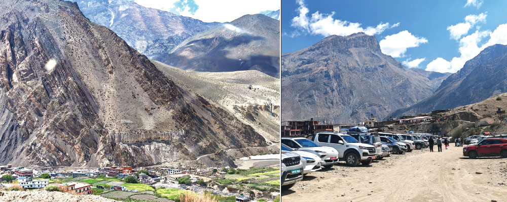
The Mustang landscape presented itself in sharp contrast to the high and craggy hills of the upper reaches of the Myagdi district we had left behind. The land gets flatter with considerably larger floodplains now occupied by the Kaligandaki River. Dry and golden brown hills made up of sedimentary rocks stand on both sides of the riverine flatland. Fertile and green oases here and there make up the farmlands and human settlements. Major town settlements along the highway include Lete Bazar, Marpha, Jomsom and Kagbeni. At the beginning of Mustang flatland, Lete Bazar looked like some western alpine town below the green hill covered with pine trees and snow-covered mountains in the far north. While we Nepalis were travelling in vehicles, Western tourists were seen hiking along the route, observing local life and unique geological wonders of this area.
While travelling further north from Lete Bazar along the Kaligandaki riverbank, the sand and pebble area covered by the river expands suddenly, presenting the glimpse of a wide valley. The river flows in divided ribbon-like lines, often changing its course as it carries sandy sediments to alter riverbed levels. “Now the river is flowing here, and a few hours later it will be taking a new course,” said our driver.
As the sandy swathes of the Kaligandaki narrow again, Marpha Bazar, the Apple Capital of Nepal, greets us. Seeing around this high-altitude town lying in the Annapurna Circuit is ideal before noon. After that, strong winds usually start blowing. Why they haven’t thought about installing wind turbines in this region to generate clean energy is a question that pops up spontaneously. Evenings are windy and chilly, and one should venture out only protected by warm outfits, as our second night stay at Marpha Orchard Hotel taught us. Jerry Galli and Marpha village provide an important window to local life, costumes and customs. This mountain town is famed for special apple products like brandy, wine, juice, jam, apple pie and Sukuti (dried apple slices). A visit in autumn offers opportunities to taste freshly picked apples and for photo/video ops about apple harvesting.
Next we arrive at Mustang district headquarters, Jomsom, which has an exotic look with the installation of western-style streetlights. Flights are operated here from Pokhara, but the plane has to land and return before 10 AM to avoid strong winds. Next on our way is Kagbeni, where we stop on the Kaligandaki bank to offer respects to deceased parents. We tried to search for Saligram stones in the river but the water was so cold we could hardly dip our hands for a minute. We were now in the trans-Himalayan district of Nepal, from where Himalayan peaks such as Annapurna, Dhaulagiri and Nilgiri were standing in the south instead of the north. How were we able to cross the Himalayan range without stepping on the snow? It was facilitated by the world’s deepest gorge, carved by the Kaligandaki, along which the highway passes. It can be estimated that monsoon winds sparsely pass through this gorge and deliver thin rain in Mustang.
Roads to Muktinath and Upper Mustang part ways at Kagbeni, which is regarded as the dividing point between Lower and Upper Mustang. From here, the road begins climbing through sharp bends, and we get the feel of the abrupt rise of altitude. Finally, we are at the foot of our destination. The marketplace of Muktinath just ahead of the vehicle park is full of hustle and bustle as puja item vendors, horse ride providers and doli (sedan chair) carriers offer their services to the visitors. It is about half an hour’s walk up the trail from the parking area to get to the Muktinath Temple. For those who are aged, weak or affected by altitude, a horse ride is provided at Rs. 400, while the palanquin, carried by four persons, costs Rs. 4,000.
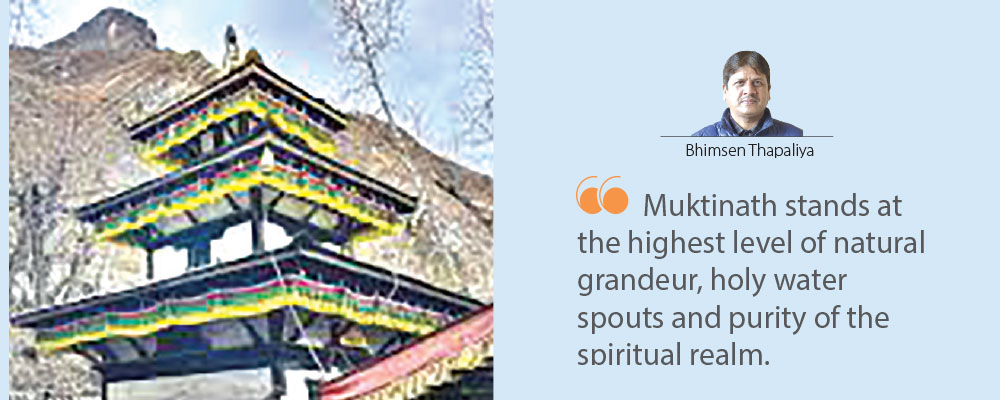
We were lucky to have a bright sunny day to take a bath in 108 holy spouts and take a dip in the pond nearby. I found the water from the spouts warmer than the one in the pond, fed by freshly melted water from a snowy source in the mountains above. Fortunately, we also did not have to stand in a long line to worship at the Muktinath temple, where a female priest offered us a handful of rice. Due to the clear and unpolluted sky, the view was superb and the sun was warm. As you look in all four directions from here, brown hills and snow-clad mountains present a unique panorama and grandeur. Our natural and spiritual experience was blessed by fine weather and a cloudless day. It was a mukti (redemption) from all dull feelings and petty concerns of life. Muktinath stands at the highest level of natural grandeur, holy water spouts and purity of the spiritual realm.
(The author is former editor-in-chief of The Rising Nepal.)