- Thursday, 30 April 2026
Meltdown Warning
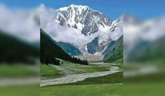
The magnificent snow-capped mountains of the Hindu Kush Himalaya (HKH), stretching in a continuous range, not only lure thousands of tourists and mountaineers every year, providing an important source of revenue to the concerned countries, but also serve as the primary source of water for two billion people living downstream. The HKH region, extending 3,500 kilometres from Afghanistan in the west to Myanmar in the east, is the source of 10 major Asian river systems. Even smaller rivers, whose waters irrigate the vast farmland across the region and are supplied to the people for drinking and washing purposes, originate in these mountains. A considerable volume of water is stored as snow and glacier ice in the HKH. However, in recent years, these water resources have come under threat due to the effects of climate change. Snow and glaciers are melting at an alarming rate, and the mountains have already been receiving less snowfall than in past decades.
Two ICIMOD reports made public on Saturday, on the occasion of the World Day for Glaciers, reveal a worrying picture. They state that glacier melt in the Hindu Kush Himalaya has doubled since 2000. The melting rate over the decades has been so intense that the region has lost up to 27 metres of ice thickness since 1975, putting the water and food security of nearly two billion people at risk. These findings suggest that the "Water Towers of Asia" are reaching a critical tipping point. More alarmingly, 12 per cent of glacier area has already disappeared, underscoring the urgent need for global action to avert a real-time crisis of floods and water shortages. Among the 10 countries in the region, Nepal and Bhutan lie entirely within the HKH and are likely to be the most affected by changes in the glacial system.
The reports – Changing Dynamics of Glaciers in the Hindu Kush Himalaya Region from 1990 to 2020 and HKH Glacier Outlook 2026: Insights from 50 Years of Himalayan Glacier Monitoring – provide some of the most comprehensive evidence of glacier change in the region. More than 63,700 glaciers cover nearly 55,782 square kilometres and serve as the source of major Asian river systems, supporting the food, water, energy, and livelihood security of billions. However, around 78 per cent of the glacier area, located between 4,500 and 6,000 metres above sea level, is highly exposed to elevation-dependent warming. Experts have warned that this is not a distant threat, but one unfolding in real-time. Without immediate measures to adapt to and mitigate the impacts of rapid glacier melt, the consequences could include catastrophic floods and growing uncertainty in water availability.
The accelerating retreat of glaciers demands urgent attention. While overall ice loss is alarming, the rapid disappearance of smaller glaciers poses immediate and localised threats, particularly to mountain communities dependent on fragile water systems. Equally concerning is the growing risk of glacial lake outburst floods, which could trigger sudden disasters. Despite these dangers, vast stretches of the region remain inadequately monitored, leaving policymakers to act with limited data. This gap is unacceptable in a climate-sensitive zone. Likewise, investing in early warning systems is no longer optional. Without decisive action, the region risks crossing irreversible thresholds, with severe consequences for water security and livelihoods.
-square-thumb.jpg)