- Saturday, 6 June 2026
Saptakosi's surface rise with river-based materials up risks
Ajit Kumar Jha and Prabesh Kumar Mishra
Inaruwa (Sunsari), Oct 8: The
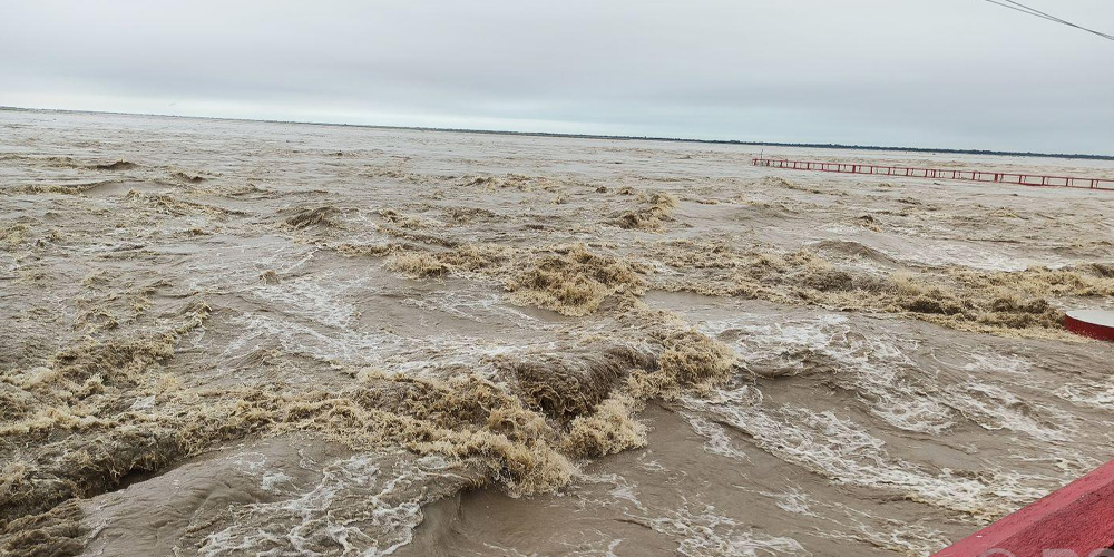
Saptakoshi River shows its nasty form when floods occur during the rainy
season. As soon as the water level in the eastern hilly district and other
major rivers rises, the flow of water in the Saptakosi river increases and the
attention of the country is focused on the river due to the devastation in the
surrounding areas.
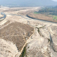
Saptakosi River when fed with
flooded water during the rainy season leaves pile-up of sand in the dry
season.
In many places, sand islands can be
seen. Those who saw these islands say, "The level of the river went high,
due to the filling of sand and pebbles in the river area. Also, the overflow of
river in the rainy season started making the residents of Sunsari and Saptari
areas miserable".
The water level of the Saptakosi
river is rising due to the accumulation of sand, mud, soil and pebbles flowing
along with the flood every year, but due to lack of its management, there is a
danger of the river water inundating the settlements.
In this connection, Nepali Congress
(NC) Inaruwa vice-president Pradip Dhakal said the problem has not been
resolved for over the years due to sheer negligence on part of the
decision-makers and stakeholders.
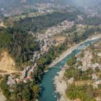
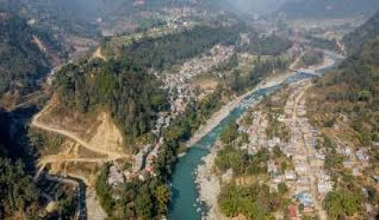
"Saptakoshi is the largest
river in Nepal, spread over a large area from Kanchenjunga in the east to
Lamtang Mountain (Gosaikunda) in the west. All these regions are badly affected
by the disaster caused by this river, which flows through the mountains, hills
and Terai of Tibet and Nepal to the Ganges River of India. Therefore, attention
should be paid to its management," he said.
The Saptakoshi River, which flows
through Sunkoshi, Dudhkoshi, Indrawati, Tamakoshi, Arun, Tamor and Likhu
tributaries, has been flooded with sand.
Dev Chandra Jha of Koshi Rural
Municipality-6 in Sunsari said with the decrease in the depth of the Koshi
River, the risk has increased in and around the surrounding areas including the
settlements.
Baburam Karki, a journalist and
expert in the Koshi region, said that the river floods come up to the
embankment and submerge the settlements every year with the rise in the ground
level of the river.
"Due to soil erosion in the
hilly and mountainous areas, the level of the Koshi river has increased. Even
when water volume increases a bit, the floods take a nasty form", he
said.
Bhim Karki, a local of
Barahkshetra-9 said that the river did not have much effect even when there was
a huge water in the past year. "The water level in Saptakosi has increased
with normal rainfall in the hilly region.
The river has been showing its disastrous form during the four months of rainy season. Sand islands have been formed here as the river is rising due to the pile-up of river-based substance flowing along with the flood. The problem is occurring every year due to the accumulation of soil and sand flowing along with the water of the river coming from the hilly areas, but the government has not paid attention to cleanliness", he said.
Vice-chair of the Saptakoshi
Inundation, Erosion and Flood Victims Struggle Committee Lal Bahadur Limbu,
said the Koshi river has been changing its course as the level has crossed its
natural border.
According to him, it is necessary
to manage sand materials from the surface to bring the river back to its own
state.
Netra Ghimire, a local, added the
river, which has the capacity to hold 900,000 cusecs of water, has menaced the
lives for the last few decades no sooner it flows 150,000 cusecs of water.
Pramod Poudel, liaison and land acquisition
officer of Koshi Planning Biratnagar, also said that the risk has increased
during the rainy season due to the accumulation of pebbles in the Saptakosi
river.
Although the problem is increasing,
they are not in a position to do anything at the local level, he said. Poudel
said, "In the agreement signed between the governments of Nepal and India
in 2011 BS regarding the Koshi Plan, Nepal's rights are limited only to the
consultation and monitoring level, so initiatives have to be taken from the
government level to solve the problems here".
Saptakoshi river was flowing
655,370 cusecs per second on last September 9 that was the alarming level. It
is known as a river that accumulates more sand than the Ganges river in India. RSS