- Wednesday, 3 June 2026
Unbridled urbanisation and river invasion trigger valley's annual deluge
By TRN Kathmandu Team,Kathmandu, Aug. 13: It was 4 in the morning on Tuesday and Subarna Laxmi Thapa was going to Koteshwor from Chyasal via the newly opened bridge at Shankhamul. “It was raining and the river seemed angry,” she noted. But she did not do a double take and went on her way.
At around 7.30 am, she received a text from the Department of Hydrology and Meteorology warning people of possible floods on the Bagmati, Bishnumati, Dhobi Khola and Manohara rivers. It had not stopped raining and even though she did not live near any of the rivers mentioned, the message did scare her. So, she opened her Facebook to see if any of her friends had posted anything about the potential deluge. They had.
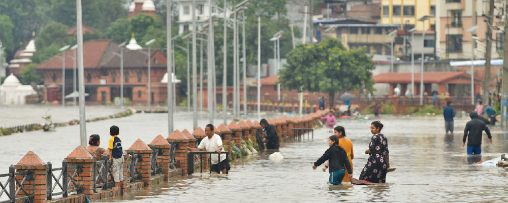
The entire Shankha Park along the Shankhamul Ghat was underwater, as were parks built on the banks of the Bagmati i River at Teku.
In Bhaktapur, Jaymangal Suwal was horrified by what he saw at Hanuman Ghat at around the same time. “The normally timid Hanumante River had swollen and engulfed the entire area.” The Shanti Niketan School and Siddhi Memorial Women and Children Hospital were also inundated.
Tuesday’s downpour submerged many areas of the Kathmandu Valley. According to the District Police Range of Kathmandu, rains at Budhanilkantha, Sundarijal and Nagarkot caused the rivers and rivulets of the valley to swell, flooding roads, schools and homes at Gaurighat, Guheshwori, Kapan, Samakhushi, Anamnagar and other areas.
Floods have become a usual occurrence every monsoon season in Kathmandu with even relatively light rains causing inundation. Kapan knows this first-hand. The area has become almost synonymous with flooding and Gorkhapatra, The Rising Nepal’s sister publication, has written a series of reports on how this is related to the near-obliteration of the Yagyamati and Chakhuncha rivers there.
The rivers u sed to flow through what are today Ward 6 of the Kathmandu Metropolitan City and Wards 10, 11 and 12 of the Budhanilkantha Municipality. But in a process that accelerated from the 1990s and continues to this day, the course of the water bodies started getting encroached or outright buried in many places.
The efforts to erase the existence of these rivers were allegedly aided by the then head of the Kapan Village Development Committee and present Mayor of Budhanilkantha Municipality Mitharam Adhikari, according to Gorkhapatra.
Gorkhapatra has also published news on how illegal pinching and plotting of the lands of Manohara and Bagmati by land mafias have been causing floods in Kageshwori Manohara and Gokarneshwor municipalities.
The encroachment of the Manohara River, in particular, was a tragedy that began with the government survey of 1964, noted Bishnu Rayamajhi, a resident of Gothatar, Kageshwori Manohara–9.
The 80-year-old who has lived in Gothatar his whole life believes that the survey registered many areas along the river’s route under private names, allowing people to build near or on the river’s pathway.
After the 1990 restoration of democracy, sand traders started haphazardly scouring the river’s bed, deepening it unnaturally. “Turns out, the deeper a river gets, the narrower it becomes,” the senior citizen recounted the torture that has been inflicted on Manohara to date.
Rayamajhi remembered how excessive sand excavation even caused the concrete bridge connecting Pepsicola to Bhaktapur to subside.
Sand mining also contributed to the degradation of the Bagmati and Bishnumati, shared Kirti Kumar Shrestha, 88. “The increase in the use of concrete from the 1970s led to a rise in demand for sand. And opportunistic individuals sought to meet that demand, and make millions, by dredging Kathmandu’s rivers,” Shrestha, who used to live near Shankhamul until the 2015 earthquake, said, adding that the “sandmen” were often in cahoots with government officials.
Sand mining around the foundation also caused the collapse of the Bagmati Bridge at Thapathali in 1991.
Bishnumati was a special sufferer. “In the late 1990s, many houses around the river were constructed with sand taken from the river,” 58-year-old Hira Kaji Dangol said.
Excessive sand mining shrunk the river. “I remember the river touching the base of the Indrayani Temple when I was a child,” he said, sharing a story that now seems like a dream.
The Bishnumati River Corridor also impinged on the river’s natural course, which could be why it gets submerged during the days of heavy rain, Dangol hypothesised. The 2.8-kilometre road extending from Teku to Balaju was built without proper planning and consideration, he complained. “If the corridor project had included sewers and drainage, it would have helped control the overflow.”
The immigration that occurred after the outbreak of the People’s War also put a pressure on the valley’s waterways. The rapid increase in population and the subsequent expansion of settlements skyrocketed the demand for commercial land.
In Gothatar, corrupt officials colluded with land brokers to illegally transfer ownership of land from one person to another and register riverbanks and public land in private name, Rayamajhi said. This further constricted the Manohara.
“As a result, when Manohara reclaims its banks in the monsoon, it submerges the structures built close to it,” Rayamajhi lamented. “The floods we see today are more a result of human greed than natural disasters.”
Meanwhile, in Dhobi Khola (Rudramati), 60-year-old Dalli Maharjan thinks that the loss of farmlands has also made floods worse.
“I have seen it in my lifetime,” Maharjan, whose family used to own fields near the Lal Pokhari locality along the river, said. “The Dhobi Khola used to break its banks much more fiercely than it does now. But the fields it flowed through would contain it. Now, those fields have grown into houses.”
“The river has changed. But its surroundings have changed even more.”
Shyam Sundar Basnet, a local of Madhyapur Thimi Municipality and Bhaktapur district chairman of CPN (Unified Socialist), said the same thing about Bhaktapur’s Hanumante. “It used to flood 20/25 years ago too, but since there were no houses on the banks, it would only submerge fields then,” he shared.
Amin Shakya, representing the Groundwater Youth Network, also said that the urban sprawl along the rivers played a role in Kathmandu’s floods. “When there are farms and forests, the porous surface drains a portion of the rainwater into the ground. Now, all that is concrete so the water accumulates above ground,” he informed.
Ironically, this concrete growth could have been driven, at least in part, by our past successes in taming the rivers. Maharjan said that embanking the Dhobi Khola prevented it from bursting its banks for many years, allowing for the construction of corridor roads and commercial and residential buildings near them. But this is exactly where the problem is.
As Shakya noted, “River-control structures like embankments prevent small floods and give people a false sense of security. As a result, they build ever closer to the rivers. This invites catastrophe when big disasters hit.”
Shakya, who has a double Masters in Flood Risk Management from the Netherlands and Germany and is currently pursuing a doctorate in Satellite Applications for River Studies at the University of Twente, also acknowledged narrowing of the rivers as a cause for Kathmandu’s floods of recent years.
Again, taking the example of Hanumante, the river that is increasingly becoming the sorrow of Bhaktapur, Madhyapur Thimi and Suryabinayak municipalities, the river once had a pathway of 150 metres. But the Kathmandu Valley Development Authority, when building 10-metre revetment walls on the watersides, only allocated 20 metres for the river’s flow and demarcated 20 metres of open land on either side, Basnet informed. “Due to this, the river has entered the settlements.”
The river also carries more sediment, pushing the water up and out into the surrounding areas. "Past floods used to sweep away wood. Now, it erodes soil, which accumulates on the riverbed," Basnet said, adding, "The river should be cleaned every year to prevent flooding."
River management and flood risk mitigation require a holistic approach that looks at a host of factors. It is not enough to only look at the cities. We have to look at what’s around and above it, Shakya stressed. “For instance, forests on the hills will prevent water from gushing down to the valley.”
Shakya also called for a more holistic management of our river basins and our cities, including stricter zoning laws that leave space for forests, farms, parks and non-concretised spaces. Most importantly, though, Nepal should invest in research and strengthening of its institutions.
Shakya emphasised that the changing climate would only exacerbate the present risks. Nepal with its challenges, as well as having a distinct importance because of the Himalayan meltwater feeding the whole South Asian subcontinent river system, is in a unique position to build its expertise on prevention of such disasters and to contribute to the global disaster resilience.