- Saturday, 6 June 2026
'Kosh' goes out of use in measuring distance
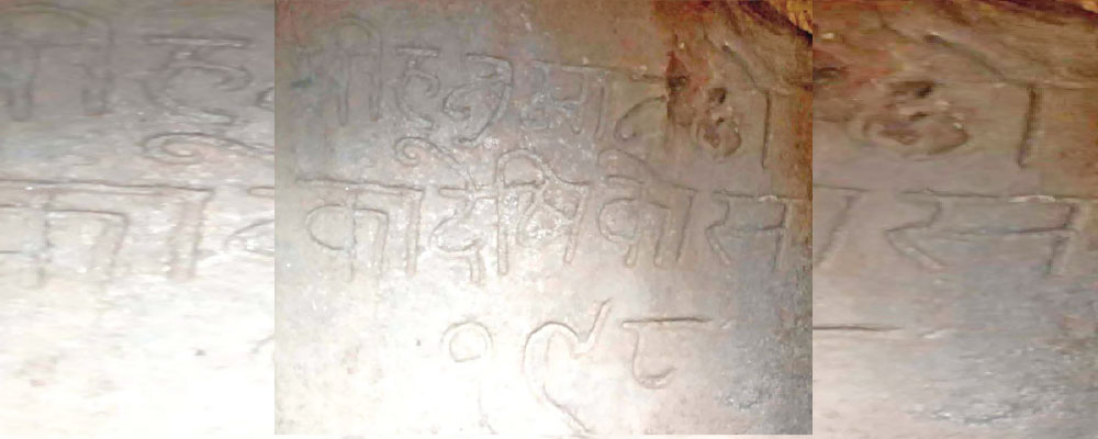
By Rajan Rawat,Humla, Dec. 31: Hidden quietly in Tuling village of Simkot Rural Municipality–7 lies a carved stone that once connected Humla to the heart of the Kathmandu Valley.
Known locally as a kosh, the historic distance marker once measured the long and difficult journey from Hanuman Dhoka in Kathmandu to this remote corner of northwestern Nepal. 1 Kosh was equal to 3021 metres. Today, it stands abandoned, an overlooked relic of a time when distance was measured not in kilometres, but in human endurance. The marker records a distance of 198 kosh from Hanuman Dhoka to Tuling. Before modern surveying and kilometre-based measurements became common, the kosh system served as the primary unit for calculating travel distances across the country.
Traders, pilgrims and officials relied on these markers to plan journeys that often took weeks on foot through rocky terrain. With the gradual shift to the metric system, the historic marker has become insignificant. “There was a time when people came here just to see it,” recalled Mandir Singh of nearby Dandafaya village. “The kosh was something everyone talked about. It helped people understand how far they had travelled and how far they still had to go. Now it has simply been left abandoned.”
For decades, the kosh system shaped daily life in Humla. Distances between Simkot, the district headquarters, and the former village development committees were commonly described in kosh rather than kilometres. Local Baliraj Shahi said the marker once held practical and symbolic importance. “All distances were determined through the kosh system,” he said. “Now it serves no practical purpose and because of that, people don’t care much about it anymore.”
Shahi expressed concern that younger generations are largely unaware of what the marker represents. “Many young people pass by without knowing its story or its value,” he said. “If this continues, an important part of our local history will disappear.” Despite its cultural and historical significance, locals say authorities have shown little interest in preserving the marker. Exposure to weather and neglect have taken their toll, and no formal efforts have been made to conserve or document the site.
Community members are now urging ward offices, the rural municipality and the provincial government to take responsibility for protecting the marker. They believe the site could be conserved as a local heritage landmark and used to educate future generations about traditional systems of measurement and travel.
This is not just a stone. It tells the story of how our ancestors understood distance, time and the land itself, locals claimed.