- Monday, 25 May 2026
Integrated Approach To Disaster Management
Nepal is highly susceptible to water-induced disasters due to intense monsoonal precipitation. Approximately 80 per cent of the country's annual rainfall occurs within four months, from June to September. This vulnerability is further amplified by the nation's rugged terrain, geologically young and fragile landscape, glacial lakes, and seismic activity. The situation has been further aggravated by the impacts of global warming, including erratic and extreme rainfall events, poor watershed and sediment management, uncoordinated and fragmented development practices, and the encroachment upon river corridors, which obstructs natural water flow during floods.
Steep slopes in Nepal's northern regions produce an extreme velocity acceleration of rivers, leading to riverbed degradation and riverbank erosion. Similarly, surface erosion across the hilly terrain destabilises slopes, usually leading to landslides. During monsoons, increased water infiltration in the soil increases the weight of the soil.
It reduces the friction between soil particles, further compromising slope stability and heightening the risk of landslides. Conversely, the flat plains of the southern Terai region contribute to slower water velocity, which expands the wetted surface area. This leads to riverbank erosion and overbank flooding – often both – causing extensive inundation of nearby settlements. These events significantly damage infrastructure, settlements, and agricultural land, leading to profound socioeconomic and environmental consequences.
The impacts of climate change have significantly intensified both the frequency and magnitude of water-induced disasters in Nepal. Reflecting this reality, the Germanwatch Global Climate Risk Index ranked Nepal as the fourth most affected country globally in 2017 based on weather-related loss events. Recent incidents of extreme rainfall, glacier lake outburst floods, landslide-induced debris flows, and widespread flooding further underscore this growing threat.
While natural hazards – isolated or compounding – cannot be prevented, communities' vulnerability and exposure can be mitigated to reduce the severity of their impacts, including cascading effects.
Much of the destruction caused by these disasters is a direct consequence of human decisions, particularly the expansion of settlements and infrastructures into areas that are inherently susceptible to such risks.
Managing the flood
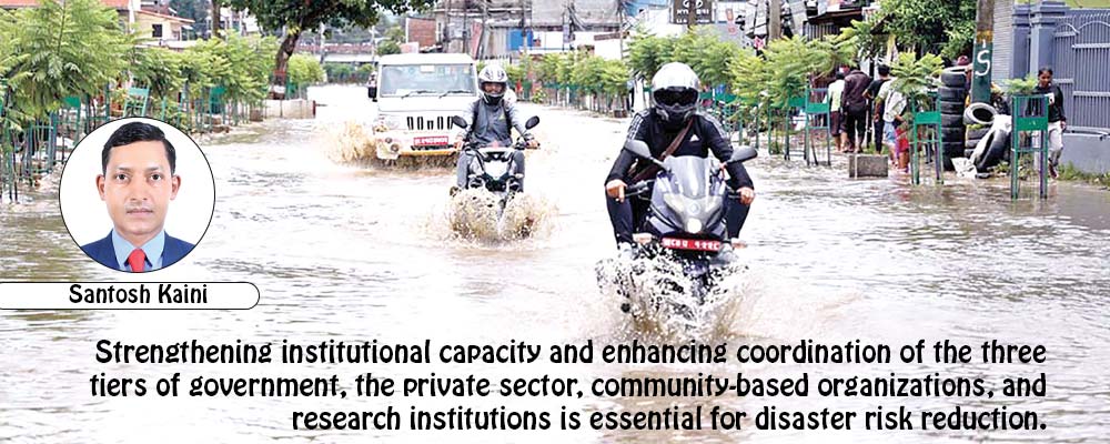
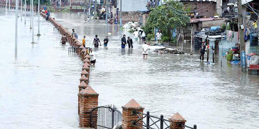
The frequency and intensity of extreme flood events have markedly increased in recent years. Contributing factors include intense rainfall, land-use changes, glacier lake outburst floods, sudden surges following the obstruction of natural river flows due to landslides, and rapid urbanisation in the watershed and river corridor. These elements collectively exacerbate river water levels, leading to riverbank erosion, overtopping, and extensive damage to adjacent areas.
For instance, heavy and long-lasting rainfall in August 2014 resulted in catastrophic flash floods and landslides in Nepal's 17 mid- and far-western districts.
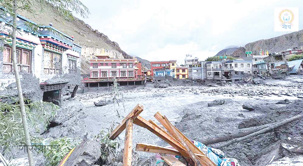
More recent events include the Melamchi flood in Sindhupalchowk (June 2021), the Kagbeni flood in Mustang (August 2023), and the Thame flood in Solukhumbu (August 2024).
On 28 September 2024, at the end of the monsoon retreat of the year, 25 meteorological stations across 14 districts – including 11 within the Kathmandu Valley – recorded new extremes in 24-hour precipitation. The severe devastation witnessed in the Kathmandu Valley has starkly demonstrated that densely populated urban areas along river corridors remain highly vulnerable to flood hazards.
Riverbed and bank erosion, inundation, and landslide problems are site-specific phenomena, primarily influenced by a complex interplay of factors. These include the river's unique morphological and hydraulic characteristics, stage and geometry, upstream hydrological conditions, land use patterns within the catchment, downstream channel configuration, and regional geology. Climatic variability, human interventions, socioeconomic dynamics, and broader environmental conditions further compound the situation.
While such processes are natural and cannot be entirely prevented, their impacts can be significantly minimised through structural and non-structural measures. In Nepal, the construction of various river training and flood control infrastructures has played a vital role in managing floodwater, thereby substantially reducing the adverse effects of flooding on densely populated areas, critical infrastructure, and agricultural lands.
Watershed management focusing on sediment dynamics has become increasingly critical in recent years. The unplanned and haphazard construction of rural road networks, coupled with debris generated from landslides triggered by slope instability from such construction, has significantly elevated sediment loads in river systems. This excessive sediment deposition has led to the aggradation of riverbeds in downstream areas, causing riverbanks to overflow under the same discharge conditions that previously posed no such threat.
In addition to poorly managed rural road development, other contributing factors – such as landslides, forest fires, and widespread deforestation – have further intensified the frequency and severity of sediment-laden flood events across various regions.
Flooding in the Terai has worsened due to blocked surface runoff from east–west highways and river embankments. Narrow waterways at bridge crossings also obstruct natural river flow. To reduce flooding, river channels must be adequately sized.
Sediment should be managed dynamically. Embankments should include drain inlets. Cross-drainage structures are needed to divert floodwaters from settlements and key infrastructure. To minimise the impacts of flooding and inundation in the Terai region, it is essential to ensure adequately sized river channels, dynamic sediment management, suitable river embankments with drain inlets, and sufficient cross-drainage infrastructure to divert floodwaters away from settlements and critical infrastructure.
Developed nations like Japan have implemented strategies including replacing outdated multi-span bridges with structures featuring fewer piers – often single-span designs – along with deepening the riverbed along the central flowline and raising embankment heights to enhance channel capacity in urban rivers. Upstream detention basins and global practices like stormwater pumping reduce flood peaks. The 2017 closure of Biratnagar Airport due to rain illustrates the impact of poor stormwater management. In critical infrastructure zones such as airports, deploying pumping systems in flood-affected areas is a highly appropriate and necessary measure.
Flood mitigation through direct intervention is often a costly endeavour. Therefore, it is imperative to adopt sustainable approaches to reduce the frequency and severity of extreme flood events. It can be effective primarily through comprehensive watershed management and sediment control.
Incorporating sustainable land use can significantly lower the cost of flood response. Rather than relying on structural measures to manage floods, top priority should be given to planning so that settlements and crucial infrastructure are located outside floodplains.
Shifting the settlement
Distancing settlements from flood hazards relies on non-structural measures. These include hazard and risk mapping, floodway allocation, and river right-of-way maintenance. Real-time weather monitoring is essential.
Communication and information sharing must be effective. Adaptive early warning systems should be implemented. Building settlements in the river's right-of-way invites disaster. Ignoring the river's natural course increases disaster risk and severity.
Effective early warning systems with real-time weather observation and high-tech communications are necessary for long evacuation periods and reduced disaster damage. The Department of Hydrology and Meteorology has utilised a telemetry-based real-time monitoring system extensively, and this has dramatically improved early warning abilities and minimised the impact of disasters in the last few years.
Nevertheless, due to the country's rugged topography, there remains a strong need to expand the network of meteorological and hydrological stations. The ministry must enhance real-time communication and information provision, particularly in the hard-to-reach and rural areas.
Furthermore, practical transboundary cooperation with China and India on real-time weather data exchange is essential, given the shared nature of river systems.
Disaster response involves saving lives, protecting property and infrastructure, and reducing the risk of further damage. It includes searching, rescuing, providing immediate relief, and setting up temporary shelters.
Disaster-related losses could be significantly mitigated if a comprehensive evacuation plan detailing destinations and routes to designated safe areas is developed before such events. Effective post-disaster planning must encompass immediate relief and long-term rehabilitation strategies, restoring livelihoods, reconstructing critical infrastructures, and enhancing community resilience against future disasters.
Integrated risk reduction
Flood management is crucial in areas with existing settlements. Implementing structural measures informed by research-based modelling with comprehensive watershed management that includes effective sediment management, integrated with cutting-edge technology and nature-based solutions tailored to local conditions, aligns with the principles of sustainable development. In such contexts, relocating entire settlements may prove more costly than investing in advanced flood protection. Therefore, adopting context-appropriate, state-of-the-art flood management technologies with new design standards and regulatory frameworks considering climate change scenarios should be practised, followed by regular maintenance.
Communities often resist allocating land for river right-of-way, preferring to retain ownership even when losing land and infrastructure to natural disaster, only to attribute the consequences to the river itself.
We must adopt sustainable practices that ensure rivers are afforded sufficient space to flow safely and naturally. Hazard risk assessment and mapping for all rivers, fixation of flood and river right of way, shifting the settlement far from the river during planning, and construction of critical structures with adequate river waterways are urgently required to minimise the recurrent losses from the water-induced disaster.
Nepal's policy on disaster risk reduction must be supported by stronger laws and more precisely defined institutional frameworks, specifying duties on all three tiers of government. Effective coordination amongst stakeholders is the solution, but it is currently inadequate.
Equally essential is an integrated and holistic approach to river basin planning, from the watershed to the exit point, considering climate change impacts on hydrological systems and past extreme events grounded in coherent policies and actionable implementation strategies. This must encompass structural and non-structural measures, supported by a strong commitment from all stakeholders to ensure effective execution.
Effective disaster risk reduction requires a dual approach: diverting floodwaters from settlement areas through appropriate structural interventions and relocating and planning settlements away from high-risk zones based on scientific, research-driven, dynamic hazard and risk mapping.
This should be complemented by establishing designated river corridors considering climate change impacts on river systems, implementing a robust multi-hazard early warning system with transboundary coordination, advanced communication and information dissemination mechanisms, and digital data innovations for decision-making.Furthermore, strengthening institutional capacity and enhancing coordination of the three tiers of government, the private sector, community-based organizations, and research institutions is essential for disaster risk reduction.
(Ph.D. holder Kaini is associated with the River and Water Induced Disaster Management Division at the Department of Water Resources and Irrigation.)


-original-thumb.jpg)