- Sunday, 26 April 2026
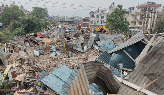
Landslide forecasting system to help save lives

Kathmandu, June 5: A new state-of-the-art artificial intelligence system that can analyse the significant amount of data needed to identify when landslide is about to take place is being installed in the landslide-prone regions of the country.
Scientists from the University of Melbourne, Australia, Tribhuvan University and the University of Florence, Italy have teamed up with the Government of Nepal and Australia’s Department of Foreign Affairs and Trade to deliver the forecasting system.
The forecasting system, called SAFE-RISCCS, continuously analyses satellite images of Earth taken by NASA, the European Space Agency and the Japan Aerospace Exploration Agency. Feeding SAFE-RISCCS forecasts’ into Landslide Early Warning Systems will protect people living in the shadow of landslides, ensuring alerts will be far more accurate, either days or even weeks in advance, says a media release issued by the University of Melbourne.
Scientist at the University Professor Antoinette Tordesillas, who is leading the project, with the monsoons due in June, we are helping policymakers and risk managers better prepare for future monsoons when increasingly frequent and heavy rains are expected to trigger more devastating landslides.
“Early warning systems are crucial because they give public officials more lead time to better plan, prepare and protect communities before the hazard strikes,”she said. Climate change and growing human activities pose a significant threat to communities in Nepal. Women, children, the elderly, and people with disabilities are especially vulnerable during disasters.
The SAFE-RISCCS platform uses images from space, combined with a new open-access artificial intelligence tool invented at the University of Melbourne, to combine rain measurements and ever-changing ground motion data to continuously monitor and forecast the risk of a landslide at any one time in any one place.
SAFE-RISCCS will be rolled out in two high-risk regions in partnership with Nepal’s National Disaster Risk Reduction and Management Authority (NDRRMA), as part of a new Landslide Early Warning System being developed in Nepal.
Prof Basanta Adhikari from Tribhuvan University said continuous monitoring of deformations in the surface was vital in protecting the people of Nepal.
“The increasing occurrences of landslides in the Nepal Himalayas, driven by the coupling effect of seismotectonic activities and climate change alongside human-made factors such as haphazard road construction, highlight the vulnerability of mountain communities,” Adhikari said.
Professor Emanuele Intrieri from Florence University said raising people's awareness about the risk affecting the area they are living in remains the most cost-effective solution to reduce the exposure.
“Nepal is only one of several regions in the Asia-Pacific at risk of worsening natural disasters associated with climate change. By improving early landslide prediction globally, we reduce the risk of catastrophic events and so protect human life, people’s livelihoods, critical infrastructure and the environment,” Professor Tordesillas said. (RSS)


-original-thumb.jpg)


-original-thumb.jpg)
-original-thumb.jpg)