- Thursday, 28 May 2026
Chure conservation far from satisfactory

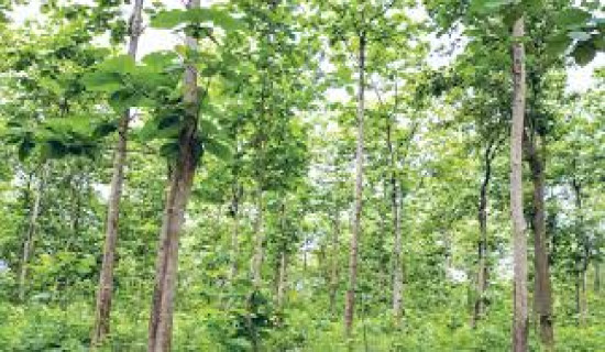
Kathmandu, June 16: The Chure-Terai Madhes landscape, which comprises the inner Terai, Chure hills, and Bhavar plains, is rapidly degrading over the last three decades due to deforestation, overgrazing, and excessive mining of construction materials.
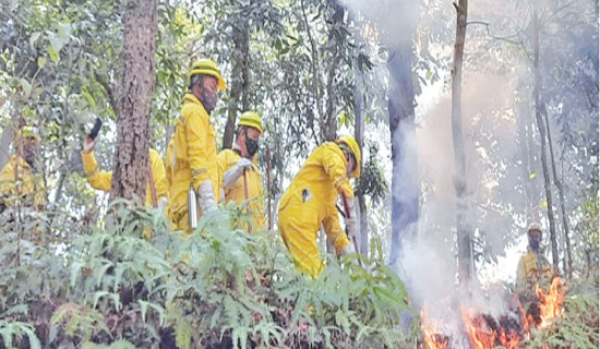
The Chure hills, the youngest in the Himalayan system, are rich in biodiversity and a source of underground water for the lowland Terai Madhes, are being over-exploited and becoming weak and fragile due to encroachment, forest fires, mining sand, pebbles and boulders from rivers and the hills.
Many plans and policies have been formulated to protect the Chure range since the establishment of President Chure-Terai Madesh Conservation Development Board in 2014, but still many challenges remain to address. Increasing floods and landslides, rapid effect of climate change as well as human intervention, make the range weaker, experts said.
According to Dr. Kiran Paudel, President of Chure-Terai Madhes Conservation Development Board, the area provides several ecosystem services to the downstream and a direct influence on the environment of around five million population of the Chure region.
“The range is structurally weak and fragile due to various natural and anthropogenic causes. Climate change has the highest impact in the region. Anthropogenic causes that are hampering the region are deforestation, forestland fragmentation, and encroachment, rural road construction, overgrazing, forest fire, cultivation on the steep slopes, and soil erosion,” Dr. Paudel said.
Why Chure conservation?
According to Dr. Paudel, Chure, one of the pride projects of the government, has been serving as the foundation of the Mahabharat range and works as a lifeline for the Terai lowland and Bhawar. The range is equally important for the livelihood of the people and vital biodiversity. It is one of the main watersheds for the conservation of surface and underground water for the plain area and lowland, he said.
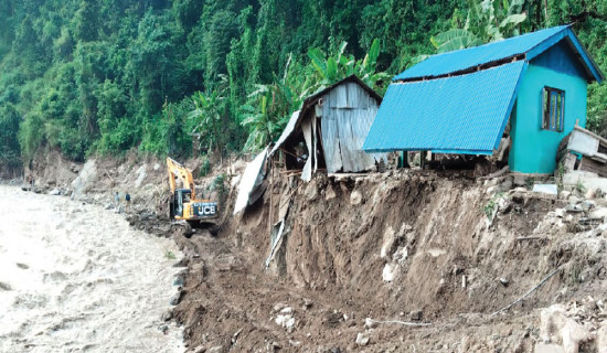
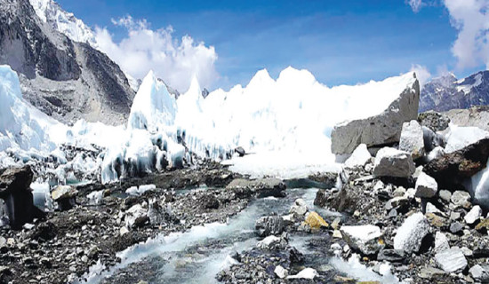
The intensity of rainfall in the area is high in the rainy season but faces drought and dryness at other times. Based on the topography, geology, and climate, the Chure range is naturally vulnerable to landslides and soil erosion. The extreme rainfall washes the property – trees, sand, mud, and soil. The flow of debris that falls from the top of the Chure enters the settlement and cultivated land on the lowland. The level of tivers rises up due to the debris deposition, which is the reason for river course diversion, Dr. Paudel said.
Different infrastructures are constructed in the range, including various roads and highways, electricity transmission lines, while railway lines are also purposed. With the growing population, there is also pressure on natural resources for the people, he said.
Most of the development activities carried out by the provincial governments and municipalities have failed to give importance to EIA, Dr. Paudel added.
Dr. Maheshwar Dhakal, Member Secretary of President Chure Board, said that our livelihood depends on natural resources, and with the increasing population and their attempst to fulfill their demands, people’s dependency has been increasing upon the forest, wildlife, and plants. After the anthropogenic activities started increasing, the government began taking initiative implementing the Chure conservation programme in the fiscal year 2009/2010, he said.
The government started 20-year Master Plan in 2017 and the Chure Board is working under the Master Plan. But again the Master Plan failed to address the problem, so the Board is planning to revise Master Plan for the next five years, Dr. Dhakal said. “We are planning to implement big and visible programme, which people can feel, for another five years. The programme will address the risk of climate change and biodiversity conservation, he added.
The budget received was very low – Rs. 12.5 billion in last five years - against an estimate of 17 billion as per the Master Plan’s demand and only small
programmes are implemented, which failed to give the desired result, Dr. Dhakal said. To mitigate the problem, budget should be allocated as per the Master Plan.
According to Dr. Nagendra Prasad Yadav, Forest and Environment Expert, said the Chure range are the youngest hills formed by the deposition of the river products around forty million years ago. The Chure extends from the Indus River of Pakistan in the West and Bharamaputra of India in the East and is also called “Shivalik” , he informed.
The over-exploitation over the Chure range creates major problems in the Terai as flooding, expansion of stream beds, sedimentation, riverbank erosion, rising river beds, inundation of villages, reduced agricultural productivity, lowering of the water table and drying of water sources, Dr. Yadav said.
According to Vijay Kumar Singh Danuwar, a former member of the Chure Board and a Chure region expert, hundreds of hectares of cultivated land in the Bhawar area has turned sterile. Around 20 to 30 bighas of land turns useless every year due to the floods from the Chure range. “It will take many years to make the degraded land into productive land,” he said.
According to Dr. Paudel, with the aim of conserving Chure, the Board has been formulating various programmes with the slogan, “Chureko Mato Chure lai: Safa Pani Sabailai (Chure’s soil for Chure: Clean drinking water for all). The government has constructed around 1,000 recharge ponds, river embankments, check dams, done tree plantations (specially bamboo), and constructed a green belt along the river.
According to the latest report (IOF 2019), more than one-third of the Chure region is highly susceptible, and 40 per cent of its region is vulnerable to landslides. The ecological, geographical, and biophysical conditions of the Chure region have rapidly degraded over the last 32 years.