- Sunday, 7 June 2026
Trekking From Helambu To Gosainkunda
As we had decided that Gosaikunda would be one of the most attractive trekking destinations for hikers like us, located in the Gosaikunda Rural Municipality of Rasuwa—covering the districts of Rasuwa, Nuwakot, and Sindhupalchok—we, eight members of Hike for Health, set out toward Kutumsang in Helambu on the day following the Bhai Tika of the Tihar festival in 2025, travelling via Melamchi from Kathmandu. A captivating roadside waterfall found along the way made the journey memorable. Around 4 PM, our vehicle dropped us in Kutumsang, which lies at an altitude of about 2,500 metres. Even though the sun was shining, the wind blowing at the top of the hill made the area feel cold. Shortly after we arrived, nature began preparing for sunset. It felt as though Kutumsang was offering us the beautiful moment of sunset as a form of hospitality.
The sunrise the next morning turned out to be another attraction. Additionally, witnessing the beauty of the peaks of Gonzala, Yala, Shishapangma, Lakpa Dorje, Jugal, and Gaurishankar mountains—standing in a row from north to east and painted with the crimson glow of the rising sun—refreshed our minds and souls. While enjoying the beauty of Kutumsang, we began our trek toward Gosainkunda at around 8 am.
We registered our details at the Langtang National Park office and paid Rs. 100 as an entry fee. The entry fee is Rs. 1,500 for visitors from SAARC countries and Rs. 3,000 for other foreign nationals. According to the information board at the conservation area office, this region is a major habitat for leopards and red pandas (Habre). With this information in mind, we walked ahead, hoping to catch a glimpse of the shy Red Panda in the trees and bushes. As we moved forward, we met two trekkers coming from the opposite direction. A brief chat with them showed that they had also enjoyed the Suryakunda area after visiting Gosaikunda. The trekking route passes through the forested area of Langtang National Park and lies within the Helambu region, one of the famous and oldest trekking regions in Nepal. The trail is fairly organised, with direction signs on pillars, stone steps, resting places, and small stone platforms that make the walk easier. However, some of these structures appeared to be in need of maintenance. After about three hours of walking via Sanu Goth, we reached Magen Goth at 11:45 a.m. As it was lunchtime, we spent about half an hour there and also met a family of foreign trekkers resting after descending from Tharepati.
As the trail moved through flat paths, steep climbs, descents, and uphill sections, everyone walked at their pace. The gentle sounds of birds and insects, along with the bright daytime surroundings, made the journey feel calm and close to nature. Steep stone steps guided us to a rocky peak area, teeming with rocks of various shapes and sizes. taking photos and admiring the beautiful stone cliffs, pillar-like rocks standing like doorways, and piles of stones Walking through colourful leafy bushes, thorny plants, and cotton-like wildflowers, we carried our bags, breathed deeply, and sweated freely. Despite the tiredness, our bodies felt light and free. Our eyes, lungs, and minds seemed to thank us for the effort. Around four o’clock, we reached a guesthouse located in the lower part of Tharepati (3,600 m) and ended the day’s journey.
The next morning at Tharepati, the ground was covered with white frost. On the right side of the trail stood a large hill, glowing beautifully in the morning sunlight. Walking through trees and bushes, mostly on flat or slightly downhill trails, we came across a long, winding downhill path that was quite steep but beautiful. Along the way, we met trekkers coming toward us, either from the Gosaikunda route starting at Dhunche or from the Langtang trek. The journey felt easier because of temporary wooden bridges and a few permanent covered wooden bridges built over small streams formed by waterfalls cascading from the giant hill on our right. The continuous sound of waterfalls and flowing streams inside the forest felt like a sweet melody to our souls. After walking for about four hours, we reached a place called Ghopte and had lunch at a roadside guesthouse.
Listening to the roar of the river flowing from the attractive waterfall on the right, we climbed a steep path, reaching Phedi (3,710 m) at around 1:30 PM. There were still scrap remains of a Thai Airways plane that had unfortunately crashed in the upper part of Ghopte Bhira in 1992 (2049 BS). It was natural to face some difficulty while gradually gaining altitude toward Upper Phedi (also called High Camp). We met trekkers descending. Most said they were returning from Gosainkunda and would stay at Talugaun, while foreign trekkers were heading to Helambu, the way we had come. As we reached High Camp (Upper Phedi) around 4 PM, the bright sun kept us warm. As the sun began to set, we found comfortable rooms and delicious food at the only guesthouse in that location (3,630 m). However, the cold was intense. We had walked an average of eight hours that day.
On the fourth day, we started walking in the twilight at 5:10 AM with the help of flashlights. Gaining altitude, the journey brought us to Surya Pass (4,610 m) at 7:30 AM. At this altitude, there is a risk of altitude sickness, but fortunately, none of us faced any serious issues, though huffing and puffing during the steep climb was natural.
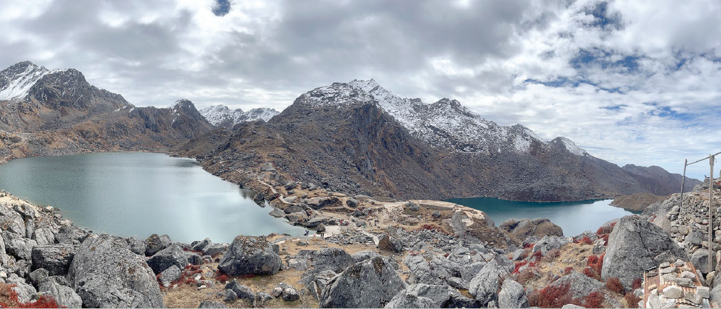
Upon stepping from Nuwakot into the Rasuwa district, we found the ground and surrounding peaks blanketed in white snow. After moving a few steps through the thick layer of frozen snow, the nearly circular Suryakunda appeared, stretching from east to north. The eastern mountains were completely blanketed in snow, while the southern peaks exhibited scattered snow. The beautiful and unique sight of those peaks reflecting perfectly in the lake water refreshed our minds. The area is filled with many lakes, including Amakunda, Mokshakunda, Chandrakunda, Raktakunda, Ganeshkunda, and Kumarkunda.
After descending for a while, we were thrilled to witness the full view of Gosainkunda (4,360 m), lying calm and steady in a nearly circular shape. It was around 9:30 AM when we reached its vicinity, a sacred centre of faith for Hindus, Buddhists, Kirats, and others. Taking a dip in the crystal-clear water brought a sense of supreme satisfaction to our restless minds and lightened our weary bodies. Trishuldhara, another famous spot, is believed to contribute a significant portion of the water that forms the kunda. Here, water falls from three spouts, believed to have been created by Lord Shiva after striking the hill with his trident while suffering from the effects of swallowing the Kalkut poison during the Samudra Manthan in the Satya Yuga.
At that time, many other visitors were also enjoying the kunda and its surroundings. There is no doubt that Lake Gosainkunda is a special combination of natural beauty and deep spirituality. Just below it lies another attractive lake, Bhairabkunda. The water flowing from Gosainkunda and Bhairabkunda is believed to be the origin of the famous Trishuli River of Rasuwa District.
The Kunda is an invaluable natural, religious, and historical heritage of Nepal and is regarded as the guardian of all the surrounding lakes. Every year, thousands of pilgrims and trekkers visit this sacred place. It can be reached via multiple routes, such as Kathmandu–Dhunche–Chandanbari–Lauribina; Dupcheshwar–Talugaun–Phedi–Upper Phedi–Surya Kunda; or Helambu–Kutumsang–Mangengoth–Thadepati–Ghopte–Phedi–Upper Phedi–Surya Kunda. The site is listed as a Ramsar site and is increasingly emerging as a major tourism destination. Religiously, a large fair is held on the occasion of Janai Purnima, and many pilgrims also visit during Ganga Dashahara. Basic facilities such as internet access and electricity are available, making the visit more comfortable and satisfying.
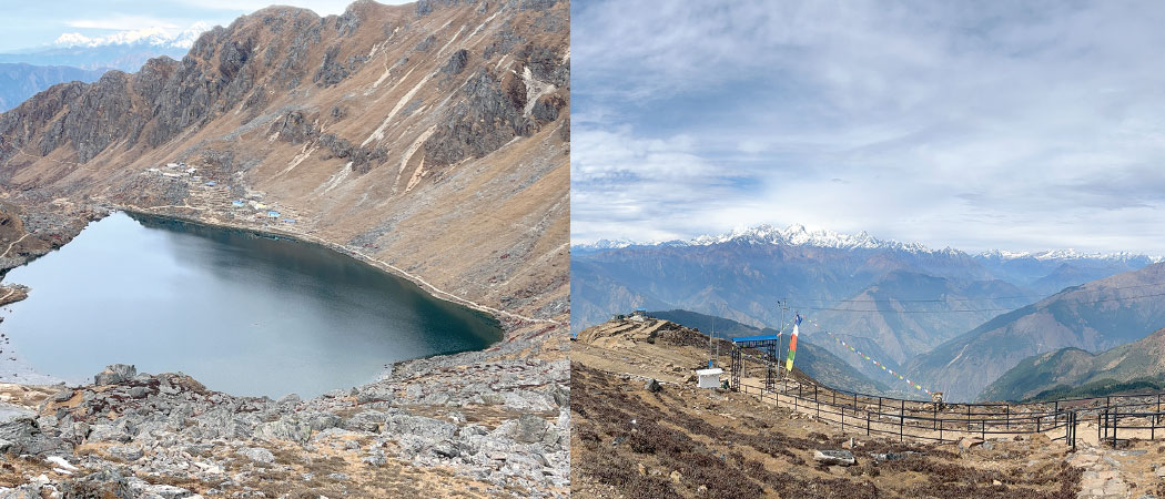
Viewing Saraswati Kunda along the descending trail, we reached the small statue of Vinayak at Lauribina. We did not encounter a single walking stick (lauri), which climbers from Chandanbari reportedly offer. This place, also known as Lauribina Pass, has rocky cliffs on one side and a deep river gorge on the other. Soon, we reached another attractive point along the Lauribina climb. A brief glimpse of what appeared to be a lone blue sheep wandering around—perhaps searching for its family or food—made the moment even more memorable.
The viewpoint offers a 180-degree panorama. The range, from Langtang, Lirung, and Ganesh Himal to Larke and Manaslu, seemed to smile and welcome us. The blue sky, white peaks, and green hills created a breathtaking scene. It felt like an artistic expression of nature. Emotions arose spontaneously in my heart. I wondered what kind of masterpiece a painter or poet might create in such an atmosphere. Below the sloping hill on the right lay Cholangpati village; straight ahead was Chandanbari and the descending trail. The climb at Lauribina is a significant part of the trekking route.
While the trail, adorned with locally built stone chortens and rhododendron trees, was attractive, it clearly requires regular maintenance. This section of Lauribina, where visitors were huffing and puffing while climbing, is quite challenging.
In the gathering darkness of the evening, we continued walking down through the forest, wondering when Deurali would finally appear. Following the trail with flashlights, we reached Deurali via Chandanbari in complete darkness. We enjoyed the coincidence of beginning our journey with lights in the morning and ending it with lights in the evening.
Guesthouse in Deurali welcomed us with a large gathering of Nepali youths, reflecting increasing youth involvement in trekking and hiking, which forms a vital link in the domestic tourism industry. Such enthusiasm makes one optimistic about new possibilities in the trekking sector.
The next morning, we walked very slowly, as the downhill trail through trees and bushes had become slippery due to the rain. After two hours, passing through Mini Gosainkunda, we reached Ghattekhola of Dhunche at 10 AM. As we entered the Kathmandu Valley through Gurje Bhanjyang, riding in an electric vehicle, the rain finally stopped, making the journey even more memorable.
(The author is working at Agricultural Development Bank Limited.)