- Wednesday, 10 June 2026
Dust storm slams Phoenix, causing damage, airport delays and power outages
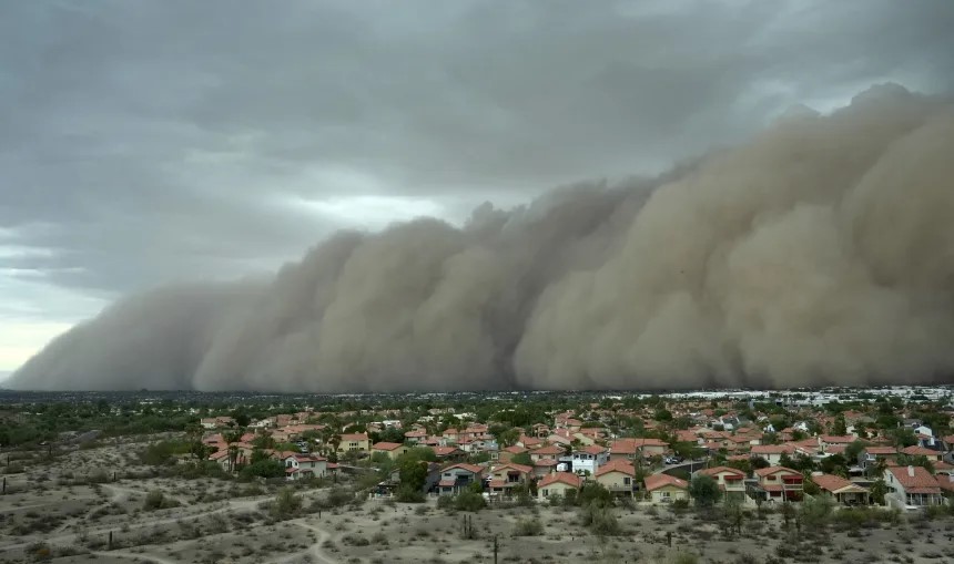
A giant dust storm approaches the Phoenix metro area as a monsoon storm pushes the dust into the air Monday. (Ross D. Franklin/AP)
By CNN Meteorologist Briana Waxman and CNN's Sarah Dewberry, Taylor Romine and Hanna Park, Aug 26: A towering wall of dust, known meteorologically as a haboob, swallowed parts of metro Phoenix Monday evening, plunging the city into near-zero visibility. The dust storm was quickly followed by severe thunderstorms that tore through the city, leaving behind downed trees, wind damage and widespread power outages. At Phoenix Sky Harbour Airport, a connector bridge was shredded by 70 mph wind gusts.
The National Weather Service in Phoenix issued both dust storm and severe thunderstorm warnings as the system pushed into Maricopa County Monday evening. The weather service warned drivers of dangerously low visibility and urged people to “pull aside stay alive.”
The Arizona Department of Transportation echoed that warning, saying there was significantly reduced visibility on I-10 and I-17 due to the dust storm and flooding on roadways, urging drivers to proceed with caution.
After the storms swept through, more than 60,000 customers in Arizona were left without power, with the majority of outages concentrated in Maricopa County, according to PowerOutage.us.
For about an hour, the Phoenix Sky Harbor International Airport had a ground stop preventing any planes from leaving or landing as a cloud of dust seemed ready to swallow up the facility. The airport was experiencing up to 30 minute delays late Monday night while crews assessed any damage or roof leaks, airport spokesperson Gregory E. Roybal said.
In Gilbert, Arizona – about 22 miles southeast of Phoenix – there are “traffic light outages and downed trees across town,” police said, urging residents to avoid travel due to dangerous conditions.
Dust storms are nothing new in Arizona’s monsoon season, but this storm packed extra punch. A thunderstorm collapsed, and its winds blasted outward, scooping up desert soil and building it into a rolling wall of dust. These walls can climb thousands of feet high and stretch for miles, cutting off the horizon in seconds, similar to a blizzard in winter.
You can see a haboob’s wall of dust coming from a distance but by the time it reaches you, it’s too late to seek shelter – especially if you’re behind the wheel of a vehicle. It’s nearly impossible to see more than a few feet in front of you in the worst of these storms as the dust chokes out light.
The haboob in Phoenix comes after a weekend dust storm in Nevada blew through Burning Man, an annual arts gathering in Black Rock City, about 120 miles from Reno.
As attendees began arriving at the remote desert location Saturday, strong thunderstorm winds kicked up a dust plume, closing access roads and sending vendors scrambling to secure their tents.
“We had to take our sign down. We weren’t expecting that,” vendor Mike Chuda told CNN affiliate KTVN. “The wind was in such a perfect angle that it was bending our booth forward. So that was pretty wild.”
The Southwest monsoon pattern isn’t quite done yet and neither is the triple-digit heat. Phoenix picked up just under a quarter inch of rain with these storms Monday, and the area has a continued chance of thunderstorms Tuesday into Wednesday before the threat eases for the latter half of the week. The heat will build throughout the week, but dry air will limit the potential for late-week thunderstorms.