- Monday, 15 December 2025
Difficulty to identify mountains from Hile
By Kabiraj Ghimire
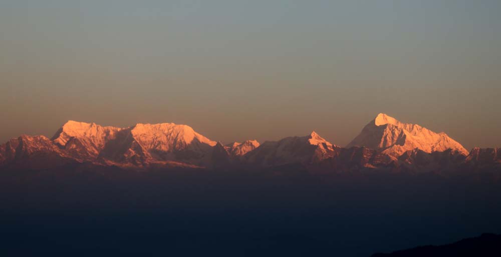
Hile, Nov. 10: Every year, Dagendra Poudel, a young man from Dhankuta Municipality - 10, takes a trip to the hills near Hile to enjoy the view of mountains on clear-weather days. Poudel is captivated by the breathtaking beauty of the mountains that stretch before him. Despite their stunning appearance, he admitted he could not identify which mountains they were.
Suman Shrestha originally from Sankhuwasabha and residing in Hile, Dhankuta for nearly four years, also sees the mountains in a line during morning walks when the weather is clear. However, like Poudel, he is unsure of the names of these mountains.
He identifies Makalu Mountain since it is located in Sankhuwasabha, he does not know the names of the other mountains. He felt that if there was a way to recognise the mountains, the experience of viewing them would be more meaningful.
From Hile, located at Dhankuta Municipality - 1, and its surrounding areas, the picturesque view of many eastern mountains can be seen from over 2,000 metres above sea level. However, apart from Kangchenjunga and Makalu, the identities of the other visible mountains have not been recognised. As a result, tourists who come to view the mountains enjoy the scenic beauty but are unable to gain any information about them.
Until about three decades ago, Hile was the main destination for both domestic and international tourists to observe the mountain. It was the primary route to the base camps of Makalu and Kangchenjunga. However, as roads expanded elsewhere, not only did the route to the base camp change, but foreign tourists also stopped visiting Hile for mountain viewing. Currently, only domestic tourists and a few Indian tourists visit Hile to observe the mountains.
Sagarmatha, the highest peak in the world, along with Kangchenjunga, the third-highest peak in the world, and other mountains like Cho Oyu, Makalu and Lhotse, are located to the east and can be seen from Hile. Similarly, more than a dozen peaks above 7,000 metres can also be seen from Hile.
From Hile, one can see most of the peaks between the 7,145-metre-high Gauri Sankar Himal and the 8,598-metre-high Kangchenjunga, located at the eastern border. There are more than two dozen peaks above 7,000 metres in this range, said the late geographer Dr. Harka Gurung in his book Bibid under the chapter Nepal's Mountains.
This issue is not limited to Hile in Dhankuta but affects many other places in the eastern region where mountains are visible.
According to Ang Chiring Sherpa, the chief advisor of the Nepal Mountaineering Association, who has worked for many years in the mountain region, this is a widespread problem. Many peaks are visible from various hilltops, but it is difficult to identify most of them, with only a few exceptions. “No one has shown interest in carrying out the study to identify the mountains visible from our place,” he said.
The areas such as Hile in Dhankuta, Jefale, Dhwajedanda, Bhedetar, Patekdanda, and Dhwajedanda Cultural Park are key spots for mountain viewing. Similarly, the areas of Tehrathum's Tinjure Milke, Bhojpur's Mundum Trail, Panchthar's Pauwa Bhanjyang, Lubrekuti, Sirauti, Ranitar, Sukepokhari, as well as Ilam's Sandakpur, Patenagi, Sriantu, Meghma and Pashupatinagar are also prominent locations for mountain observation.
Beautiful mountains can be seen from most of the ridges in Sankhuwasabha and Taplejung, though locals report difficulties in identifying many of the peaks, except for a few.
Recently, there has been an increasing demand from both tourists and locals for the identification of mountains.
According to tourism entrepreneur Shreeram Rayamaji from Hile, Dhankuta, the middle hills are an ideal location for those who cannot reach the mountains but wish to view them.
He suggested that designating specific spots for mountain viewing, along with the use of photographs or markers to help identify the peaks, could enhance the importance of the mountains. This would not only increase the number of tourists but also improve the overall experience.
“There is a large group of people who are interested in learning about the mountains, and for the residents of the Tarai and Bihar in India, the middle hills are the closest and most accessible destination for mountain observation. If promoted and provided with more information, the number of tourists in the middle hills will increase,” Rayamaji said.

