- Thursday, 4 June 2026
The Civilisation Of Simraungadh
Ram Dayal Rakesh
The economic, social, cultural, political and artistic civilisation of the eleventh-century town of Sirnraungadh is no longer with us now, but the perishing of whatever remains has compelled us to rely on stories that relate our history like fairy tales.
The Roman Catholic priest Cashiani De Macherata had drafted a map of Simraungadh and that map was carved into stone at the palace of the king of Bhadgaun (present day Bhaktapur). He had inspected the monuments during the 18th century, according to the stone inscription.
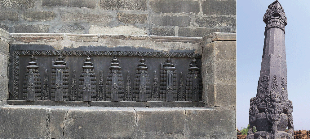
Monuments
His description tells of a town having many winding paths for access, making it difficult if one lost the way, the town being surrounded by seven tall walls, canals in between the walls and four forts that needed to be crossed before entering through a single door. A Tibetan scholar, Dharmaswami, who met King Ramsingh Dev of Tirhut in 1236 A.D. has also mentioned these features.
Madan Kumar Rimal says according to the excavation and study done by an Italian archaeologist in 1992 the area was surrounded by a security wall which was rectangular in shape and 7.5 km long north-south, 4.5 km east-west. The walls were covered with baked bricks and surrounded by canals.
The area south of the Gadh (fort) lies at present in Champaran district of Bihar, India. The present borders came into being after the Sugauli Treaty of 1816. Simraungadh now falls in the territory of Nepal.
In ancient times, King Nanyadev of Karnatak in South India attacked the Mithila Kingdom in 1097 A.D. That kingdom had borders up to Koshi in the east, Gandak in the west, the Himalaya in the north and the Ganges in the south. He made Simraungadh his capital.
Archaeologists say the name Simraungadh was derived from the simal or cotton tree (locally called simar), found plentifully there. The name has been formed the word from Simar Ban (forest) and Gadh (fort). Similarly, this area is also named variously in different books as Videha, Mithila, Tirbbukti, Tirhut, Brihadarankya, Naimikanan, Janaki, Janmabhumi, Shambhavi, Swornalangal, Gyanchhetra, Kriyapith and Tapoban.
Sultan Gayasuddin, the Tuglak dynasty king of Delhi defeated King Harishinghdev in war in 1324 A.D. and brought to an end the 229 year Karnat dynasty which was considered a golden age in view of the economic, political, religious, literary, and artistic developments of the time.
Sultan Gayasuddin was not content with the capturing of Simraungadh, but also destroyed the town, demolishing monuments of archaeological importance including shrines and temples and artefacts which were second to none. Hari Singh Deo fled to the hills after his defeat. This fact has been stated in the history.
"Hindu tradition, eked out by a couple of Sanskrit slokas, a copy of which I subjoin, asserts that Simroun was founded by Nanyupa Dev (A.D. 1097). Six rulers (Nanyupa, Ganga, Nara Sinha, Rama Sinha, Sakti Sinha, Hari Sinha) all with the cognemen Deva of the dynasty reigned there with great splendour; and that the sixth, by name Hari Sinha Dev, was compelled to abandon his capital and kingdom, and take refuge in the hills in A.D.1322. The Moslem annals give 1323 for the date of the destruction of Simroun by Toglak Shah.
Plenty of idols of gods and goddesses both intact full length and in broken state, earthenware and old bricks and other valuables straddle the villages of this area such as Laxmipur, Kotwali, Bhagawanpur, Dewapur, Hariharpur, Uchidi,, Kachorba, Amritgunj, Golagunj, Khajahani, Nayakatola and Jhamari.
A famous scholar B.H. Hodgson has written about Simraun Garh in his work Illustrations of the Literature and Religion of the Buddhists as follows:
"It was only with difficulty that my elephants could make their way through the jungle; and when I had reached a central position, and ascended an elevation of some 25 feet, composed of the debris of the palace, nothing but a wilderness met my eye. Yet it is barely 300 years since Simroun was a pukka-fortified city, the pride and the defence of Mithila.
The people of the locality say they find many artifacts while building houses and while cultivating, but they hide these artifacts either in their own houses or underground, for fear of harassment by the police.
In the study and research conducted by the Department of Archaeology in 1991, 1992 and 1994, it was found that Simraungadh was made a fort by surrounding it with water, forest, and earthwork, and while excavating earthenware, notices, inscriptions, metal idols, stone carvings, rosaries of stones of the Doya era, Muslim coins, and remnants of Hindu and Buddhist religious artefacts were also found, according to archaeologist Chandra Prasad Tripahi who was also involved in the excavation project.
Among the 52 Gandas (One Ganda is equal to four ponds) believed to be built between the 11th and 13th centuries in Simraungadh, most of the ponds and wells have disappeared now and the remaining few are also on the verge of being buried due to lack of proper care and maintenance.
The area of the Jharokhar pond (which includes seven wells) at Kachorba village bordering India is spread over an area of 52 bighas and has now been reduced to 28 bighas, says Reader Namonarayan Jha. At this place, people from India come for picnics and other entertainment on January I each year.
The temple of Kankalimai at Golagunj village (the idol of Kankali Mai has broken limbs and waist) the cemetery of Mansaram Baba and the temple of Bhairav Nath, the idol of Parasnath Baba found while digging a paddy field at Kachorba VDC, the Kamaleswor Mahadev idol found six months ago at Hariharpur VDC and the Ram Janaki Temple built by son of Jung Bahadur Rana Jitjung, at Raniban in Amritgunj VDC are regarded as very important from the archaeological point of view.
Likewise, the artistic stone work made out of an enormous rock which is called the Tijori Bakas (box of treasure) located at the south of Hariharpur village (which is estimated to have contained invaluable wealth), the hillock at Kotwali village (where we can still find bricks, roofing tiles and burnt lumps of clay), the Ishara Pokhari of Golagunj and the burnt rice found in the mound adjoining the security fort south of Kankali Mai are perhaps awaiting more research.
A Municipality Now
It is also estimated that we can find immense wealth in valuables in Khajahani at Amritgunj village which was supposed to be used by the then kings for keeping their wealth. Local residents have not forgotten the incident some 50 years back when a farmer fled to lndia after he found one maund of gold while digging a canal.
Time also saw the development of tantricism in the area of Simraungadh and very important and great works could be carried out with that learning, as mentioned in various books. But archaeologists have not accepted this due to lack of concrete evidence.
“Simraungarh was a fortified city and the main capital of the Tirhut kingdom founded by Karnat king Nanyadev in 1097.
At present it is a municipality located in the Nepal-India Border, 28-km from Birgunj and some 160 km south of Kathmandu. The Kankali and Ranibas are famous temples situated here. These are two Karnat period monuments but now neglected by the municipality as well as the Madhes Pradesh. Now it a dead city. So I request the UNESCO body to make it a creative city.
(The author writes on cultural issues.)