- Sunday, 15 February 2026
Urbanisation And Land Transition In Nepal
Urbanisation has been rapidly increasing worldwide in recent decades, with more than half of the world's population now residing in urban areas. This trend is expected to continue, with the world's population projected to grow by more than two-thirds by 2050, and reach 11.2 billion by 2100. Much of this growth is anticipated to occur in the urban centres of Asia and Africa. Nepal, a developing country, is one of the least urbanized countries in the world. However, it is one of the top ten fastest urbanizing countries, with a growth rate of 18.2per cent per year, and has witnessed haphazard Urbanisation in recent decades.
This rapid urbanisation in Nepal has been driven by factors such as population growth, rural-to-urban migration, changing definitions of urban areas, and an increase in the number of metropolitans, sub-metropolitans, and municipalities. Nepal cannot escape the effects of globalization and Urbanisation, as they are spreading throughout the world.
Conceptually, the definition of urbanisation in Nepal has been consistent but has evolved over time. The census of 1952/54 provided data on ten prominent settlements with a population of over 5,000. In 1961, the term "urban area" was defined for the first time as an area with a population cluster of 5,000 or more and having an urban environment, such as high schools, colleges, judicial and administrative offices, markets, communication facilities, mills, and factories.
The Nagar Panchayat Act of 1962 established the designation of Nagar as a local-level urban administrative entity, as opposed to a local-level rural administrative unit. The act stated that a population of not less than 10,000 was usually necessary for a locality to be granted municipal status, but this was not sufficient. In 1976, the population size criteria to receive municipal status was reduced to 9,000.
After the restoration of the municipality system in 1990, the Municipality Act of 1992 and the Local Self-Governance Act of 1990 were endorsed and renamed the early notation of "Nagar Panchayat" by Nagarpalika (Municipality) based on population size, density, occupational structure of the population, and infrastructure. Currently, the Local Government Operation Act of 2017 categorizes urban areas into three layers: Metropolitan City, Sub-Metropolitan City, and Municipality, respectively, based on population, size, annual average income, and infrastructure.
In 2011, 17.1 per cent of Nepal's population resided in urban areas, with 58 municipalities. By 2014/15, 40 per cent of the population resided in 217 municipalities. Currently, there are six metropolitan cities, 11 sub-metropolitan cities, 276 municipalities, with a total of 753 local bodies. The share of the urban population is 66.8per cent (CBS, 2021), with over half residing in hills and the rest in Terai.
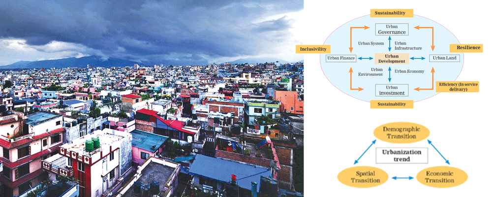
In Nepal, three major transitions are seen which effect Urbanisation trends:
Demographic transition: Major people entering the labor force than are leaving it
Spatial transition: Resulting from increased migration from country side to towns and cities
Economic transitions: Declining contribution of agriculture to GDP, demises of traditional subsistence economy, search for new livelihood
Thus increasing urban growth and Urbanisation are consequences of these transitions. The acceleration of Urbanisation in Nepal results in extensive changes in quantity structure and spatial patterns of land use land cover types. Urban expansion results in habitat destruction, resource loss, bio diversity loss, declination of natural vegetation cover, loss of arable lands, loss of water resources and fragmentation of landscape. The conversion of lands to build up areas at the expense of natural ecosystems and arable lands reduces the flow of ecosystem services.
Urbanisation has led to changes in land-use and land-cover, resulting in a decrease in ecosystem services and an increase in urban heated islands, pollution, solid waste, and groundwater levels. As a result, urban development has become a primary driver of environmental and ecological changes in terrestrial ecosystems. In Nepal, several factors, such as politico-administrative boundaries, internal migration, centralized development, and emerging trends of the spatial economy, have contributed to rapid Urbanisation. Moreover, the momentum transformation from rural to urban economy due to the change from unitary to federal state has been a crucial factor in this process.
The Kathmandu Valley is the most urbanized valley in Nepal, and its urban pattern is characterized by unplanned urban development and poor enforcement of regulations. Consequently, there has been rapid and uncontrolled urban sprawl, leading to dramatic changes in the valley's urban footprint. If urban development continues, both infill in existing urban areas and outward expansion will put unprecedented stress on the valley's land resources.
Geologically, the Kathmandu Valley is as vulnerable as Haiti, and haphazard urban development has exposed an increasing percentage of the population to seismic hazards. In addition, emergency services have decreased their capacity to cope with disasters due to the accumulation of debris on narrow roads, making it difficult for fire brigades and ambulances to provide services.
Agricultural land has been reduced due to the lack of strong government policies to protect agricultural lands and the rapid Urbanisation process. The younger generation is not attracted to agricultural practices as farming is not considered a reputed and lucrative profession, which has further reduced the agricultural land. Moreover, agriculture has received minimal investments from the government and non-government sectors, and the inability of the government to bring private investments, poor market opportunities, and political unwillingness to support agriculture have led to agriculture abandonment and a reduction in agricultural lands.
To address these challenges, the government of Nepal has formulated different policies and rules to protect agricultural land and plan urban and rural land properly. The Land Use Policy 2012, Land Use Act 2076, and Land Use Regulation 2079 guide the categorization of land of every local body into ten categories: Agricultural area, Residential area, Commercial area, Industrial area, Mining and Mineral area, Forest area, River and Wetlands area, Public land area, Cultural and Archaeological Important area, and Other Important area assigned by the Nepal Government.
There are certain indicators to allocate these areas guided by land use regulation-2079. Thus after making land use map according to the land use categorization. zoning of each local bodies will be formed and planned urban/rural area will be attained in near future. There are many other planning and policy guidelines which help for the proper urban planning and urban land development like: National transport policy 2001, National agricultural policy 2004, National urban policy 2007, Industrial policy 2011, land use policy 2012. Recently National urban development strategy 2017 is being implemented whose main motto is to establish benchmarks and standards for urban infrastructure, urban environment, urban planning and management and urban governance. It has suggested new approaches to Urbanisation and urban development in emerging challenges of sustainability, resiliency, mitigation and adaptation of climate change.
Urbanisation and urban development are significantly influenced and guided by key policies of government sectors, such as education, transport, communication, agriculture, tourism, industry, energy, environment, etc., in addition to the policies followed in urban areas in Nepal. The interpretation of the urban environment condition is critical in terms of the existing physical, natural, socio-economic, and cultural environment.
The availability of social overhead capital, such as water supply, sewage, drainage, health, sanitation, housing, road transportation, reveals the urban deficiency. However, in developing economies, including Nepal, there are no strong policies and guidelines to respect, preserve, and conserve urban and rural land. The legal and institutional framework is weak in the context of Nepal. The Urbanisation process is jeopardized and influenced by political power, with political interference disturbing the planning and development sector. It is concluded that systematic urbanisation is a symptom of development and would be more appropriate for a developing country like Nepal. Proper land use planning, zoning, and categorisation, along with clear rules and regulations, are needed to accelerate the regional balance, rural-urban balance, and sound, inclusive, and broad economic development policy in reality.
(The author is an architect and urban planner at Bharatpur Metropolitan City Office)

