- Friday, 5 June 2026
Glacial Lakes Threaten Himalayas
The escalating climate risks in the Himalayas are highlighted by the flash floods at the Rasuwagadhi border between Nepal and China in July 2025. Glacial Lake Outburst Floods (GLOFs), driven by rapid glacial melting, are no longer isolated or unprecedented events, as they are becoming alarmingly frequent across the region. The ongoing warning trend in the Himalayas is a driver of glacial melt, contributing to the expansion of glacial lakes. However, this temperature trend and associated anomalies must be scientifically substantiated with robust and sufficient data.
At approximately 05:45 on July 8, 2025, a GLOF occurred in Jilong County, Tibet Autonomous Region (TAR), China, causing a rapid rise in the water level and impacting the downstream part of the Nepal-China border at Rasuwagadhi. A sediment-laden flood occurred in the Bhotekoshi River (known as the Lhende River in the TAR), sweeping away the Miteri Bridge (Nepal-China Friendship Bridge) and resulting in substantial human and economic losses. Preliminary observations indicate minimal rainfall on both the Nepal side and the TAR of China at the time of the incident. These conditions suggest that the sudden onset of the flood was likely driven by glacial lake dynamics, possibly due to the failure of a moraine-dammed lake and/or a supraglacial lake. According to the National Key Laboratory of Geohazard Prevention and Geoenvironment Protection at Chengdu University of Technology, China, 55 glacial lakes, with a total area of approximately 3.39 km², are distributed in the upstream basin of the Friendship Bridge. Sentinel-2 imagery from July 8 confirmed that the flood originated from the outburst of a glacier ice lake upstream of Purep Zangbo. The lake had expanded from 0.28 km² on June 10 to 0.60 km² by July 5, then shrank to 0.46 km² after the breach. Post-event Sentinel-1 imagery analysis showed a further reduction to 0.81 km². This indicates a transition from a rapid outburst to slow drainage, explaining the continued high discharge in the Donglin Zangbo River. The exact size may vary depending on the resolution of satellite imagery.
This flood also caused significant downstream channel changes, including widening at several points. Remote sensing revealed that the flood path followed the glacier surface, with several small supraglacial lakes still present. In addition to supraglacial lakes, several moraine-dammed areas with evidence of dried-up lakes are also visible.
Although such events are not new, they are becoming increasingly common in high mountain areas, and both GLOFs and Landslide Dam Outburst Floods (LDOFs) are rising. Recent events such as the Melamchi flood in Sindhupalchowk district (June 2021), the Birendra Lake flood in the Manaslu area (April 2024), the Thame flood in Solukhumbu district (August 2024), and the Limi Valley GLOF in Humla district (May 2025) are some of the prominent events of the devastating impacts Nepal has faced. Detailed scientific investigations with thorough, efficient hydrometeorological monitoring stations are paramount to address these disasters properly. Glacial lakes typically form due to glacier retreat, which often leaves behind large debris deposits. These lakes can develop within eroded landforms (e.g., bedrock-dammed lakes) or be impounded by moraines, ice, or debris. According to ICIMOD, Landsat imagery from 2015 was used to map glacial lakes equal to or larger than 0.003 km² in the Koshi, Gandaki, and Karnali river basins, the TAR of China, and India. A total of 3,624 glacial lakes were identified, of which 47 were classified as Potentially Dangerous Glacial Lakes (PDGLs): 41 in the Koshi, 3 in the Gandaki, and 2 in the Karnali basin. Among these, 25 PDGLs are located in the TAR of China and flow towards Nepal, 21 are within Nepal, and one is in India. However, earlier reports didn’t explore the presence of smaller glacial lakes that triggered the flood during the GLOF event in the Thame area in 2024. This event suggests that such studies are still insufficient to detect the smaller lakes and even to understand the glacier lake dynamics. But an obvious fact is that these recent studies by ICIMOD (2020), Dou et al. (2023), and Khadka et al. (2024) highlight the accelerating retreat of glaciers and the corresponding increase in glacial lake areas, underscoring the rising risk of GLOFs in the region.
Glacial lake formation and outburst mechanisms are dynamic processes and require periodic study. Similarly, the monitoring systems need to incorporate high-resolution satellite images that can capture lakes smaller than 0.003 km². To understand the detailed mechanism of such GLOF-triggered floods, periodic monitoring and evaluation are required for both glacial and supraglacial lakes, as supraglacial lakes often merge and migrate downslope, contributing to the expansion and instability of terminal or lateral moraine-dammed lakes. Time-series satellite imagery (e.g., Sentinel-2, Landsat), UAV-based surveys, and high-resolution DEMs should be used to track these lakes' formation, growth, and drainage patterns. Detailed geomorphological and geotechnical assessment of the moraine dam is equally critical, as these dams are typically composed of unconsolidated debris with varying permeability and structural integrity. A detailed field investigation is also required to understand the nature of subglacial and englacial lakes. Investigation should assess distance from glacier source to lake formation, dam height, width, internal composition, seepage zones, and buried ice or permafrost within the dam, which can significantly weaken the dam over time. A thorough meteorological and hydrological assessment is needed to evaluate the role of rainfall, snowmelt, and temperature anomalies using data from automated weather stations, satellite-derived climate datasets, and hydrological models. To understand the dynamics of the flood, hydraulic modelling should be employed to simulate the breach outflow, flood wave propagation, and inundation extent. The river basin’s slope and surface roughness are other key parameters that help us understand the hydraulic behaviour of the river. Understanding the interplay between supraglacial lake dynamics, moraine dam stability, and hydrometeorological triggers is vital not only for reconstructing GLOF-triggered floods such as the Rasuwagadhi event but also for designing a robust early warning system and mitigating strategies for similar high-mountain hazard zones.
The measures to understand the GLOF-triggered flood are the data deficiency and a lack of proper understanding of the hazards' cascading and compounding nature. To overcome these challenges, increased automated weather stations, cross-border collaboration specifically with China, and interconnectedness of multi-hazards need to be established. For instance, heavy rainfall, earthquakes, landslides, debris flows, and GLOF-triggered flash floods and their cascading mechanism, where one hazard triggers another, and their compounding impact are critical issues to be explored in the high mountains. To capture the broader dynamics of the glacio-hydrological system, comprehensive river basin-scale studies are crucial to perform that integrate hydro-social and ecological aspects. Without scientifically justified knowledge, prioritising effective mitigation measures is challenging; consequently, implementing nature-based solutions may fall outside our immediate focus. Establishing effective disaster preparedness and early information mechanisms within the country requires strong collaboration among governments, academia, UN agencies, I/NGOs, bilateral and multilateral organizations, and local communities. The National Disaster Risk Reduction and Management Authority (NDRRMA), under the Ministry of Home Affairs, Government of Nepal, must strengthen coordination with academic and research-based institutions, maintaining close coordination with other key government bodies such as, but not limited to, the Department of Hydrology and Meteorology, Department of Survey, Department of Mines and Geology, Department of Water Resources and Irrigation, and Water Resources Research Development Centre. Such integration is essential to ensure coherent action and avoid duplication of efforts.
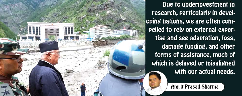
We must learn from past occurrences to better prepare for future events. The key is to foster meaningful collaboration with academic institutions to generate localised knowledge and solutions. Without sustained investment in research, achieving the Sendai Framework for Disaster Risk Reduction goals, the Paris Agreement, and the Sustainable Development Goals (SDGs) will remain elusive. Due to underinvestment in research, particularly in developing nations, we are often compelled to rely on external expertise and see adaptation, loss, damage funding, and other forms of assistance, much of which is delayed or misaligned with our actual needs. This dependency undermines our ability to define and pursue our priorities, leaving us vulnerable to externally imposed agendas and weakening our long-term resilience efforts.
(Sharma, a PhD holder in hydraulic engineering from Tsinghua University, China, is currently working as an assistant professor in the Department of Environmental Science, Patan Multiple Campus.)