Friday, 26 April, 2024
By A Staff Reporter
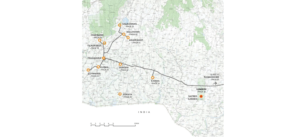
Kathmandu, Apr. 10: The Lumbini Development Trust (LDT) has been surveying three districts - Rupandehi, Nawalparasi and Kapilavastu - with a concept of developing Greater Lumbini Master Plan to include other sites related to Gautam Buddha.
The Greater Lumbini Area (GLA) comprises three districts withthe UNESCO World Heritage Site of Lumbini in the centre. The GLA contains hundreds of archaeological sites, some directly associated with the life of the Buddha.
Member Secretary of LDT Sanuraja Shakya said that a consulting agency has been conducting a study in the three districts for last six months after the formation of the Greater Lumbini Area Development Planning Committee. The study time, which was to expire on April 13,has been extended for three months till mid-July.
Member Secretary Shakya said that the study process was obstructed due to the lockdown last year. The DPR process of the master plan will start after the submission of the study report.
Karma, Dohani, Niglihawa, Araurokat, Saghahawa, Chatradei, Kudan, Gotihawa, Sisaniya and Ramgram are the major sites to be included in the master plan.
Karma, the fort, was first formally studied by the team from Durham University between 2016 and 2017 under the coordination of the Department of Archaeology.
Dohani may be one of the longest occupied sites in the Greater Lumbini Area to protect the archaeological remains. In 2016, it was first formally studied for a geophysical survey to identify subsurface archaeological features across low rectangular mound.
The excavations in 2017 identified that the fort had brick ramparts. Possibly dating back to 1000 BC, the pottery and material of clay on top of an earlier settlement at Dohani are very similar to Lumbini’s Village mound.
Niglihawa Pillar was found with inscriptions from Asoka and King Ripu Malla. It was moved in 1996. It was found in the Niglisagar pond in 1895 by Dr. Fuhrer and the inscription was translated in 1896 by Georg Buhler.
P.C. Mukherji mapped the Araurakot for the archaeological survey of India in 1899. The 2015 survey revealed that the interior was largely empty, except for a raised platform in the south-west corner with foundations to two buildings.
Sagarahawa is an expanse of large and small mounds, clustered around a water tank. The excavation in 1896 by Dr. Fuhrer exposed the remains of large brick monument and smaller buildings at the western edge to the tank, as well as 17 small brick stupas. The stupas were interpreted as commemorative of the deaths of the Shakyas during the destruction of Kapilavastu by Virudhaka.
It was identified that Sagarahawa as “the place of the massacre” visited by the Chinese pilgrim in the 7th century BC.
Chatradei is now densely covered with vegetation. Its excavation was carried out by P.C. Mukherji in 1988. Gotihawa has a large brick stupa of an Asokan pillar and a water tank. Sisaniya includes 260 metres long mound and a small circular mound measuring 200 metres.
Ramgram has attracted archaeological interest in 1896. The most remarkable feature of the site is its massive stupa, which is 10 metres high and 23.5 metres in diameter.

Do not make expressions casting dout on election: EC
14 Apr, 2022
CM Bhatta says may New Year 2079 BS inspire positive thinking
14 Apr, 2022
Three new cases, 44 recoveries in 24 hours
14 Apr, 2022
689 climbers of 84 teams so far acquire permits for climbing various peaks this spring season
14 Apr, 2022
How the rising cost of living crisis is impacting Nepal
14 Apr, 2022
US military confirms an interstellar meteor collided with Earth
14 Apr, 2022
Valneva Covid vaccine approved for use in UK
14 Apr, 2022
Chair Prachanda highlights need of unity among Maoist, Communist forces
14 Apr, 2022
Ranbir Kapoor and Alia Bhatt: Bollywood toasts star couple on wedding
14 Apr, 2022
President Bhandari confers decorations (Photo Feature)
14 Apr, 2022