Friday, 26 April, 2024
By A Staff Reporter
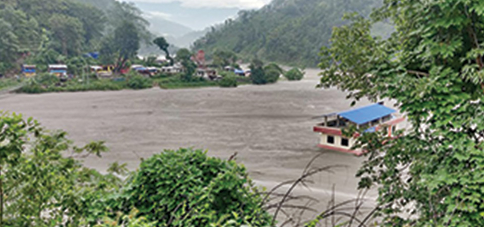
Kathmandu, Aug. 6: The Melamchi disaster of June15 and the subsequent days was the result of multiple man-made and climatic factors, concluded a recent report of the International Centre for Integrated Mountain Development (ICIMOD).
It attributed factors including weather condition, snowmelt and erosion of glacial deposits, glacial lake outburst, landslide and river damming, new landslide, riverbank erosion and debris deposition to the disaster which killed five and swept away 20 people and damaged property worth billions of rupees.
Experts also cited possible earthquake impact behind the devastating floods that deposited debris in Melamchi Bazaar and buried houses, fields and other properties.
“The Melamchi disaster of June 15 and the following days cannot be attributed to a single factor. It was the result of multiple anthropogenic and climatic factors and processes that occurred at various locations along the Melamchi River,” read the report.
According to it, the Melamchi-Indrawati watershed receives high precipitation, which increases, along with altitude, towards the north. This disaster was initiated by intense precipitation in the upstream areas, which triggered cascading hazards along the river corridors, causing loss of life and extreme devastation to settlements, markets, roads and bridges, and local livelihoods.
Both the Melamchi and Indrawati basins started receiving rainfall from June 9 as recorded in the automatic weather station of the Department of Hydrology and Meteorology (DHM) at Sermathang, located at an elevation of 2625 metres above sea level. On June 11, Sermathang recorded more than 100 mm of daily rainfall. During the six-day interval, the station had, therefore, received more than 200 mm of rainfall.
According to the DHM report on pre-monsoon rainfall monitoring, the daily accumulated rainfall from March to May was 129 per cent above normal, which shows that the watershed had experienced significant precedent precipitation.
The automatic weather station (AWS) operated by ICIMOD at Ganja La in the upper Yangri Khola shows that just four days before the occurrence of the most significant mass flow events, air temperature had risen significantly suggesting a transition to heavy snow melt, according to the report.
It said that both pre-monsoon precipitation events and the two cyclones, Yaas and Taukte, resulted in significant amounts of snow in the headwater areas of the Melamchi watershed. Rapid snow melt and high precipitation resulted in the erosion of glacial deposits in the headwaters of Pemdang Khola, Yangri Khola and Larke Khola.
It is estimated that glacial deposit erosion occurred over an area of approximately 70,000 m² in the headwaters of Pemdang Khola, stated the report.
The new landslide, 550 metre wide at the bottom, at the east of Melamchigaon on the left bank of the Melamchi River deposited about 670,000 cubic metre of debris on the river blocking its flow.
“This blockage would have got filled up with debris flowing from the upstream area. Eventually, the river would have overflowed the landslide by eroding and cutting the damming material and breached out, causing the catastrophic flood that resulted in major damage to the downstream areas,” read the report.
Stating that cascading hazards are becoming more common in Nepal and in the Hindu Kush Himalaya, the report suggested that it demanded a more holistic approach in hazard assessment and risk management.
The report prepared by 11 scientists and researchers also suggested establishing early warning system in the watershed with strong involvement from upstream and downstream communities, supported by local and national government entities.
The study was based mainly on remote sensing information, and a rapid field assessment in the downstream part of the watershed should be augmented by aerial observation and detailed field investigation, particularly in the upstream high-altitude area of the watershed.

Do not make expressions casting dout on election: EC
14 Apr, 2022
CM Bhatta says may New Year 2079 BS inspire positive thinking
14 Apr, 2022
Three new cases, 44 recoveries in 24 hours
14 Apr, 2022
689 climbers of 84 teams so far acquire permits for climbing various peaks this spring season
14 Apr, 2022
How the rising cost of living crisis is impacting Nepal
14 Apr, 2022
US military confirms an interstellar meteor collided with Earth
14 Apr, 2022
Valneva Covid vaccine approved for use in UK
14 Apr, 2022
Chair Prachanda highlights need of unity among Maoist, Communist forces
14 Apr, 2022
Ranbir Kapoor and Alia Bhatt: Bollywood toasts star couple on wedding
14 Apr, 2022
President Bhandari confers decorations (Photo Feature)
14 Apr, 2022