Thursday, 25 April, 2024
Jiba Raj Pokharel
The Democratic Republic of Nepal has embarked on the twin aspirations of Prosperous Nepal and Happy Nepali. The 15th Five Year Plan has formulated a long-term Vision 2100 for this dream to come true. In this context, accessible modern infrastructure and intensive connectivity, development and full capitalisation of human capital potential, high and sustainable production and productivity and high and equitable national income are expected to coast towards the accomplishment of prosperous Nepal.
Similarly, well-being and decent life, safe civilized and just society, healthy and balanced environment, good governance comprehensive democracy, national unity security and unity are expected to create happiness in every Nepali.
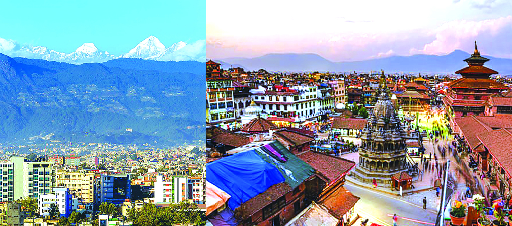
In order to realise the aforementioned national desire, Nepal has to have good urban areas. China has shown how the creation of one city after another has propelled it towards the dizzy height of prosperity. Our capital city Kathmandu in turn languishes at the bottom of the global livability ladder. It attained a sorry rank of 124 in the list of 140 cities round the globe according to a survey carried out recently by much read magazine the Economists.
City Planning Heritage of Nepal
Nepal had a very good planning concept right from the times of Gopals, the cowherd dynasty that ruled the country the first time in its history with their capital near Matatirtha in the south-west corner of Kathmandu. They labelled the hilly area as highland (Lek), midland (Kacchad) and lowland (besi) adjoining the river.
The habitation was in the midland on account of its cool environment in the summer and warm in the winter. The streams on either side supplied the required water for drinking and sanitation. The following Abhiri dynasty and Kirats also continued with this three layered planning. Their planning was organic with similar orientation of the houses mostly facing either east or south to let the warm sun to light and heat the living areas.
The following Lichhavis however used a diagrammatic city based on the Vedic city patterns and the treatise of Chanakya known as the Chanakya Arthashastra. They were the fabulous Sarbhatobhadra form for Brahmins, Swastika for Chhetris, Chaturmukha for the Vaisyas and Karmukha for the Surdras.
The river would be in the north and shelter fearful dead and semi dead entities like burning ghats and ghosts as well as the goblings. The south side was for the living with charismatic temples and palaces. The city would consist of three roads aligned towards the cardinal direction east to west and north to south.
The center would host stunningly beautiful palace square consisting of the temples, palaces, dabus, patis and the likes.
It would be complimented by the market squares, the community squares and the domestic squares. Whilst the courtiers would live in the space surrounding the palace for the security of the King, it would be encircled by the business persons followed by the farmers with the sweeper caste in the outer periphery. This form was used by the Thakuris, Mallas and the Shahas as well as Ranas.
Post Democracy Era
The democracy era of the post fifties carried on this tradition in the planning of Rajbiraj, the first planned orthogonal city in Nepal by adopting the Prastara form after the observation of Jaipur the renowned city of that time. But it also made a departure from the age old practice and planned Tikapur along the modern lines of Chandigarh designed in India.
Nepal forgot its planning lesson after this with some attempts here and there such as Mahendra Nagar and Birgunj. After this planning manifests in bits and pieces in the form of Sites and Services, Guided Land and Land Pooling Projects which are not even a shadow of the former shelf.
A Nepal Urban Dialogue virtual conference held in the capital city has been caught in this debate. The challenge is to have cities,which fulfill the requirement of the present with the identity of the past. This is the concern of virtually everyone these days including UNESCO which has also advocated for culture led development to all its member countries.
Nepal has been like a beggar seeking for alms in a golden bowl. We have such a long time city planning heritage. But we are aping the western planning methods. One American presenter made a very enlightening presentation in the aforementioned seminar but she began from the city of Savannah dating back to 1733 when the General James Ogglethorpe had landed in the bank of river Savannah with 120 passengers of the good ship Anne.
In Nepal, Hadigaon the capital of Licchavis was already planned in the Swastika city form by almost the fifth century.
Example of Singapore
It is not however that there are no ways out of this troubled water. Singapore is one burning example. One may say that Singapore is an island and not a country.
But now we have many local Governments in the Municipalities both urban and rural of the size of the island country or even bigger. Singapore was virtually a spark away from being a slum country in view of rising slum population in between 1947 to 1950.
But the adoption of the Masterplan followed by series of Perspective Plans made it into a global city. Now they have emphasized on quality of life, ageing population, sustainability and above all identity.
Despite their excellent achievement, they feel that they have yet to do much in the front of identity.
How To Create Identity
Now the question arises as to how can identity be created. For this, each municipality should focus on their peculiar aspect. It could be like poet Bhanubhakta or grass cutter. Renzo Piano, an Italian architect, was invited to plan for Genoa, the native town of Christopher Columbus where he designed a ship resembling open pavilion, which made Genoa very spectacular as Columbus travelled in the ship. Similar kind of a show can be created in the center of the municipality, something like our palace square around which Government offices can be created using local architecture as Piano did in the design of Kanak Cultural center.
The roads can go east west and south west as in our ancient towns. In the periphery could be modern buildings even skyscrapers. This way the municipality will reflect its identity in the city core and modernity in the peripheral areas.
For this there have to be Master Plans followed by several Perspective Plans as prepared by Singapore.
But merely having masterplans in paper is not enough, these should be implemented on the ground.
Development at the cost of identity will not bring the much-needed satisfaction in the long run. So, identity should be created through the assimilation of innovation and essence of our heritage.
Identifiable urban areas among so
many others can contribute towards creating the much sought after prosperous Nepal and happy Nepali.
(Pokharel is former vice chancellorof NAST)

Do not make expressions casting dout on election: EC
14 Apr, 2022
CM Bhatta says may New Year 2079 BS inspire positive thinking
14 Apr, 2022
Three new cases, 44 recoveries in 24 hours
14 Apr, 2022
689 climbers of 84 teams so far acquire permits for climbing various peaks this spring season
14 Apr, 2022
How the rising cost of living crisis is impacting Nepal
14 Apr, 2022
US military confirms an interstellar meteor collided with Earth
14 Apr, 2022
Valneva Covid vaccine approved for use in UK
14 Apr, 2022
Chair Prachanda highlights need of unity among Maoist, Communist forces
14 Apr, 2022
Ranbir Kapoor and Alia Bhatt: Bollywood toasts star couple on wedding
14 Apr, 2022
President Bhandari confers decorations (Photo Feature)
14 Apr, 2022