Saturday, 20 April, 2024
Bhimsen Thapaliya
The cloudless and sparkling sky of Kathmandu in mid-November is so mesmerising it inspires a floating spirit like that of a free bird. Washed clean by monsoon rains and still untouched by the thick haze from across the border, this time offers the best view for nature lovers, especially those of the snow-capped mountain in the north. Neither foggy-chilly nor rainy-muddy, the enchanting weather recently continued for days, opening a rare opportunity for nature trips and sightseeing.
Better Timing
The timing could not be better when the COVID-19 infection and illnesses are rapidly declining, heating the domestic tourism activities. The cloudy disturbance is common in Kathmandu, and one has to be really lucky to see the best view that continues for days uninterrupted. A climb up the Swayambhunath stupa provided the best view of the mountain peaks but it could not satiate the inner quest in me for taking a closer and more panoramic view of the Himalayan mountains. This is where the idea of going on a mountain flight was born.
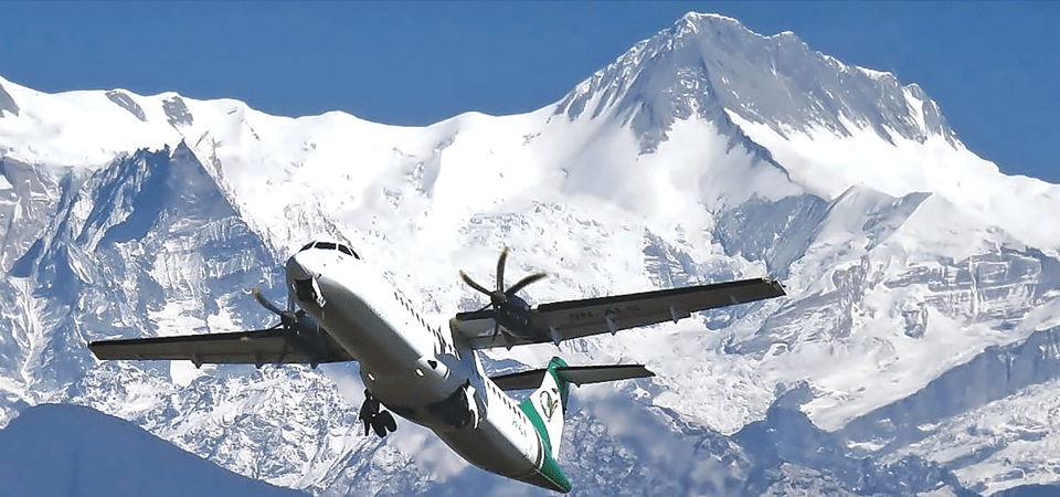
The best moments in life are captured when we do not err by procrastinating and postponing things. Dwelling over this thought inspired me to take a flight for a bird’s eye view of the crystal peaks. We decided to experience the service of Yeti Airlines which has earned a name as the first carbon-neutral airline of the country under UNDP facilitation. Saturday seemed to be an ideal day for the flight as it coincided with weekly off at the office. It was a sign of the country’s tourism activities reviving from the pandemic-hit atmosphere that mountain flights were being operated again.
You have to rise early and set out to the airport early even before the golden rays have fallen on the mountains. It called for setting an alarm on the clock as my profession mostly dictates me to keep the midnight lamp burning, making it cumbersome to rise very early. The morning of November 13 had to be an exception to our usual routine as we were instructed in the ticket to report to the airport one and half hours before the 6:30 flight time.
As we emerged from the domestic lounge of the airport to board the bus taking us to the aircraft, however, we felt our anticipated joy was marred by the unexpected weather. A layer of dark cloud was hovering over our heads as if it was going to rain soon. Clouds have come back after a series of crystal clear days! We talked of the cloudy day as we boarded the plane and took our seats. But as the aircraft took off and gained height, our displeasure went away. We were above the layer of clouds engulfing the capital valley and golden rays of sun brightened our mood and moment. Low lying cloud layer mattered little to enjoy the view of the mountains. As the mass of clouds underneath looked like a huge pile of cotton, mountain peaks in their sparkling glory started to come in view in the north. We left mountain villages behind and the snow-capped mountain range appeared closer and closer. No cloud, no haze, no mist all over the mountain range.
We were seated in the right row of the plane, and with the plane starting towards the east, it was the turn of the passengers in our opposite row to have the first view of the mountains. We could enjoy the closest panorama when the plane completed its eastward flight and turned back. “The view on the return trip is even better as the aircraft flies closer to the mountains,” one of the air hostesses told us. The air hostesses were clad in PPE for protection from coronavirus and everyone was advised to maintain distance from strangers. One of my colleagues who was not taking the flight had said that the 45-minute flight might not even reach Mt. Makalu and adjoining range in the east but to our sweet surprise, the flight attendant showed us the Mt. Kanchenjunga range in its vivid view before the plane turned and started west. Then, for us in the right seats, Mt. Makalu (8463 m) appeared in its pyramids like elevation followed by rather a low lying Mt. Chamlang (7319 m) and Mt. Amadablam (6812 m). Then the elevation of the mountains started to rise with Mt. Lhotse (8516 m) coming next in view. Then, to our excitement, Mt. Sagarmatha (Everest), the tallest mountain in the world popped into our view. The height of the mountain was recently revised to be 8848.86 metres. With Mt. Lhotse (8516 m) and Mt. Nuptse (7855 m) standing in the foreground, Sagarmatha truly dominated the mountainscape.
Mt. Pumori (7161 m), Mt. Cho-oyu (8201 m), Mt. Karyolung (6511 m), Mt. Numbur (6957 m), Mt. Chugimago (6297) and Mt. Melungtse (7181 m) stood long in line, looking similar in height. Some peaks appeared higher in height just because they were located in the southern front of the range and nearer to us. Others located in the far north appeared lower though they were actually in greater heights. Even the side-tilting of the aircraft sometimes gave the impression of declining and rising altitude though there was no marked descent of the aircraft.
The air hostesses were attending us individually presenting the description of the mountains and answering our queries. They had to approach us at a hearing distance but were well protected with visors, goggles and gloves because of the virus risks that have not come under complete control yet. The air hostesses drew our attention towards two peaks in higher view saying, “Now you can see Mount Gaurishankar with two separate peaks, one a bit flat and the other is pointed.” Some passengers were even greeting the mountain with religious respect. The higher peak on the northern side is Shankar or Shiva and the one on the southern side is Gauri, the consort of Shankar. For religious reasons, Hindus are not allowed to climb this mountain with a height of 7134 metres located in Dolakha district. Nepal Standard Time (NST) has been determined from this mountain peak.
Smart Air Hostesses
Next, coming in view were Chhoba-Bhamare (5970 m), Dorje Lakpa (6966 m) and Langtang Lirung (7234 m). Meanwhile, I wanted to know where Ganesh Himal was. It is the mountain where the river Netrawati (Ankhu Khola) originates and flows down my home district Dhading. The air hostess showed the well snow-capped peak in the far-west of our view but the plane started to descend and head south towards Kathmandu. It was well past an hour when we landed at Tribhuvan International Airport.
The cloud that spoiled our early morning mood was clearing slowly. Given the fantastic weather and better post-vaccination COVID scenarios, a mountain flight is worth your budget. But if you want to take a cue from my flight experience, please make sure your seating does not happen beside the wing or its rotor that annoys you with an interrupted view.

Do not make expressions casting dout on election: EC
14 Apr, 2022
CM Bhatta says may New Year 2079 BS inspire positive thinking
14 Apr, 2022
Three new cases, 44 recoveries in 24 hours
14 Apr, 2022
689 climbers of 84 teams so far acquire permits for climbing various peaks this spring season
14 Apr, 2022
How the rising cost of living crisis is impacting Nepal
14 Apr, 2022
US military confirms an interstellar meteor collided with Earth
14 Apr, 2022
Valneva Covid vaccine approved for use in UK
14 Apr, 2022
Chair Prachanda highlights need of unity among Maoist, Communist forces
14 Apr, 2022
Ranbir Kapoor and Alia Bhatt: Bollywood toasts star couple on wedding
14 Apr, 2022
President Bhandari confers decorations (Photo Feature)
14 Apr, 2022