Friday, 26 April, 2024
Shyam Prasad Mainali
A border is what separates the ownership of land generally between two countries. As every country tries to own a bigger size of the cookie at the cost of others' borders, disputes between nations take place. Border problems, therefore, are common in most countries, and it has been one of the root causes of bilateral disputes. The border dispute between Nepal and India is one such case.
Due to the unregulated border system between Nepal and India, such problems have escalated. Interpretation is made for unilateral benefit by the bigger nation. The border issue is a sensitive topic that can lead to disputes and diplomatic distress and ruin friendly political relationships and people-to-people affiliation.
Geopolitics is no longer limited to neighbours any longer. We can look for patterns by reframing geopolitics to re-examine the past, experience the present with a new perspective and anticipate the future. Efforts are made in this article to highlight the problem of Kalapani areas and how the Indian side ignored and the Nepali government neglected these issues in different periods.
Problems in Kalapaani Areas
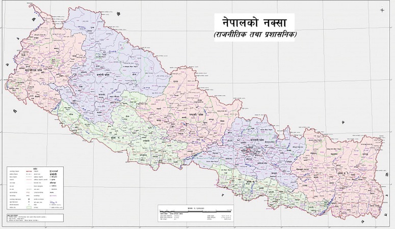
The Kalaapaani border dispute has become a serious problem at present where, strategically, 37000 hectares of our land is taken forcefully by India. In the beginning, Indian military troops were permitted to construct the international airport in Kathmandu in 2009 BS. Since the defeat of the Indo-China war in 1962, India decided to continue to station its troops in the Nepalese territory to watch and monitor the Chinese activities from Nepal. To fulfil this purpose, On 19th Jun 1954, the outposts manned by Indian army personnel were established in 18 points of the northern border, including Kalapani.
Concrete documents are available to prove that this area falls inside the Nepalese territory. Biswa Bandhu Thapa, former Minister of Nepal, clearly stated that Indian troops were stationed in Kalapani, based on a clear bilateral understanding between the then King of Nepal, Mahendra, and the then Indian Prime Minister, Nehru.
Formal correspondence on this understanding was made through a formal channel that must have remained secured in the Ministry of Foreign Affairs. With full intention to occupy Nepalese territory permanently and to include these areas in her part, India maintained an artificial source of the Kali River as a national boundary so that they could claim the area as their land. Now they have been making claims to the land behind the river as their own.
The Sugaulee Treaty of 1816 had mentioned that all these disputed areas, including Kalapani, had belonged to the territory of Nepal. The treaty is an authentic document where the source of the Mahakali River is mentioned as the border in Article-5 of the treaty.
In the survey map prepared by China in 1903, Limpiyaadhura is pointed out as a Nepalese territory. The Kalapani area was the territory of Nepal as depicted on the maps of 1850 and 1856 published by the survey of India. India is not prepared to accept these shreds of evidence.
They claim the map of 1975 was entirely prepared unilaterally by the Indian side whereas the document is not certified by Nepal. The origin of the Kali River lies either in Limpiyaadhuraa or in Lipulek pass and both areas belong to Nepal.
The Indian side argues that the river Kali is originated from a smaller river, later named Pakhaagad, which lies at the southern part of Kalapani and the subsequent ridge on the eastern part is the true border.
Negligence
Missed are the opportunities to resolve this burning issue. Then Rana rulers Mohan Shumsher and Babar Shumsher failed to demand our greater Nepal territory with East India Company. The Peace and Friendship Treaty of 1950 with India has nullified the treaty signed in 1816, 1817, 1823 and 1860. However, based on the amendment made in August 1947, Nepal must claim all territories. Let us have a look at these documents that say, "We are leaving the four parts- the Sikh, Maratha, Mughal and Gorkha of Nepal in the similar condition where we had first taken it, everyone should rule according to their border".
All the post-1951 premiers have also failed to take up the border issue with India seriously. On India’s part, when major political changes happened in a different period in Nepal, the Nepali territories are being occupied in a period of transition. Some citations could be presented as Kalaapani Limpiyaadhuraa and Sustaa after 2007 BS; Sustaa was occupied after 2036, Tanakpur, Maheshpur, Thori, Sustaa, Sandekpur, Manebhanjyang, Pashupati Nagar, Bhantaawari, Kakadbhitta bridge area after 2046 BS. Lalbhajanee and Bhajanee of Kailali, Gulariyaa of Bardiya, Parasan Paratal, Susta after 2062/063 BS, Shree Antu of Ilam, Soveshworaa of Chitwan, Jhitkaiyaa of Bara, Koilabas of Dang after 2065, respectively. The 372 km area has encroached and the road to Manasorobar is being constructed in the Limpiyadhura area.
India is encouraged to occupy Nepalese land because our politics is highly influenced by Indian politics. The Nepali government did not approach the issue seriously enough to take the area back from India and did not publicise the bilateral document, clearly understood at the time of the establishment of the Kalapani checkpoint.
Serious disputes have been raised about the origin of the Kali River, both parties are claiming the origin point of the river in their own way. Maps of Nepal excluding these Kalapani areas were amended and published in the Panchayati regime and this was removed from the high school curriculum of Nepal. The then Prime Minister, Kirti Nidhi Bista, removed 17 Indian military outposts from Nepal except for the outpost situated in Kalapani. The constitutions of the democratic era published in 2047, 2063 and 2072 BS did not mention these areas in the political map of Nepal.
Nepal amended the political map by including disputed areas as its own but further actions were not taken to resolve this problem because the purpose of the government behind publishing the new political map was to save its face and win support from the patriotic citizens.
The Mahakali Treaty inked on 12 February 1996 completely ignored the military presence at Limpiyaadhuraa and Kalapani, through it was a great opportunity for the Nepalese side to come to a common understanding of this issue. Because the treaty helped the Indian side take a heavy benefit from our water resources.
The Nepal-India joint technical committee had been formed in 1981, claimed that disputes regarding 98 % of total disputed areas have been settled and disputes about Kalapani and Susta parts are under process to be identified. The Nepali side did not approach well to finalise a bilateral understanding of the settled issues. India deputed paramilitary security guards along the border whereas the presence of Nepalese security forces on the border is almost nil.
In November 2019, the Indian government unveiled its political map that included the disputed Kalapani region in the greater Himalaya lies as part of India. In this regard, diplomatic correspondences between the two countries were issued. To date, the dispute over the origin of the Kali River has continued.
India is determined to occupy these areas permanently. The issue of the Kalapani area may disrupt other aspects of Nepal-India ties, especially in the domain of economy, foreign relations and our dependence on India for trade and transit as well as cross-border security as well. This area has been of strategic significance in South Asian diplomacy as it serves as a tri-junction. A proper demarcation of these areas has not yet been done.
Conclusion
The territory of Nepal is lost and the local people are facing obstructions in the mobility in their areas. Humla is a significant economic loss due to the diversion of the tourists from Simikot's Mana Sarowar route to Kalapani.
Both countries must chalk out their borders in a formal and friendly manner. India should think immediately and come out of its strong reservations regarding its security issue with China. In this context, Nepal should act as a mediator between China and India if such problems arise.
Both countries, especially Nepal, should be determined to resolve these issues through amicable dialogues. Nepal should learn the lessons from the peaceful settlement of the Indo-Bangladesh border issue.
Though a large portion of Bangladesh territory fell into India, Bangladesh became successful getting back 43000 bighas of land in May 2015 through the relentless dialogues of 44 years with India.
(The author is former secretary,
Government of Nepal, a freelance writer, social worker and author of books. He can be reached at : mshaym@nema.edu.np)

Do not make expressions casting dout on election: EC
14 Apr, 2022
CM Bhatta says may New Year 2079 BS inspire positive thinking
14 Apr, 2022
Three new cases, 44 recoveries in 24 hours
14 Apr, 2022
689 climbers of 84 teams so far acquire permits for climbing various peaks this spring season
14 Apr, 2022
How the rising cost of living crisis is impacting Nepal
14 Apr, 2022
US military confirms an interstellar meteor collided with Earth
14 Apr, 2022
Valneva Covid vaccine approved for use in UK
14 Apr, 2022
Chair Prachanda highlights need of unity among Maoist, Communist forces
14 Apr, 2022
Ranbir Kapoor and Alia Bhatt: Bollywood toasts star couple on wedding
14 Apr, 2022
President Bhandari confers decorations (Photo Feature)
14 Apr, 2022